Reinach geodata
Reinach (Aargau) is a populated place; located in Switzerland in Europe/Zurich (GMT+2) time zone. With population of 7,845 people, there are 205 cities with bigger population in this country. Compared to other cities in Switzerland, 52.7% of cities are located further ↓South; 55.9% of cities are located further →East and 60.7% of cities have lower elevation than Reinach. Note1


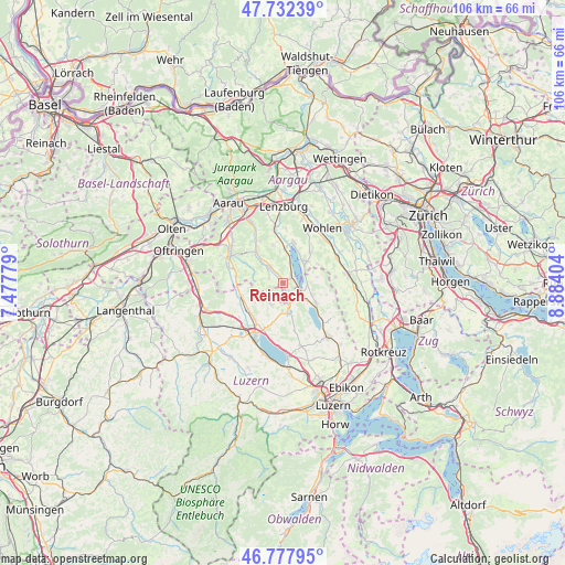
Reinach GPS coordinates[2]
47° 15' 26.352" North, 8° 10' 51.276" East
| Map corner | latitude | longitude |
|---|---|---|
| Upper-left | 47.73239°, | 7.47779° |
| Center: | 47.25732°, | 8.18091° |
| Lower-right: | 46.77795°, | 8.88404° |
| Map W x H: | 106.1×106.1 km | = 65.9×65.9mi |
| max Lat: | 47.76737° ⇑47.3% North |
| Reinach: | 47.25732° |
| min Lat: | ⇓52.7% South 45.83203° |
| min Long | Reinach | max Long |
| 5.97153° | 8.18091° | 10.44624° |
| W 44.1%⇐ | ⇒55.9% E |
Elevation
Elevation of Reinach is 523 m = 1716 ft, and this is 35.2 m = 115 ft below average elevation for this country.
| Max E: |
1845 m = 6053 ft | 39.3% |
| Avg. | 558.2 m = 1831 ft | |
| Reinach | 523 m = 1716 ft | |
Min E: |
197 m = 646 ft | 60.7% |
See also: Switzerland elevation on elevation.city.
Geographical zone
Reinach is located in North temperate zone (between Tropic of Cancer and the Arctic Circle). Distance of this North polar circle is 2146.7 km =1333.9 mi to North.| Distance of | km | miles | from Reinach |
|---|---|---|---|
| North Pole | 4752.5 | 2953.1 | to North |
| Arctic Circle | 2146.7 | 1333.9 | to North |
| Tropic Cancer | 2648.6 | 1645.8 | to South |
| Equator | 5254.5 | 3265 | to South |


Nearby cities:
15 places around Reinach: (largest is in red/bold)
• Aesch
4.5 km =2.8 mi,  91°
91°
• Beinwil
1.9 km =1.2 mi,  78°
78°
• Beromünster
5.8 km =3.6 mi,  171°
171°
• Birrwil
3.9 km =2.4 mi,  18°
18°
• Boniswil
6.7 km =4.2 mi,  5°
5°
• Dürrenäsch
7.3 km =4.5 mi,  346°
346°
• Gontenschwil
3.2 km =2 mi,  299°
299°
• Gunzwil
5.2 km =3.2 mi,  181°
181°
• Hitzkirch
7.3 km =4.5 mi,  120°
120°
• Leutwil
5.9 km =3.7 mi, 354°
• Meisterschwanden
5.5 km =3.4 mi,  40°
40°
• Menziken
2.1 km =1.3 mi,  160°
160°
• Oberkulm
6.4 km =4 mi,  316°
316°
• Pfeffikon
1 km =0.6 mi,  194°
194°
• Unterkulm
7.7 km =4.8 mi, 319°
Sources, notices
• [Note1] Compared only with cities in Switzerland existing in our database
• [Src1] Map data: © OpenStreetMap contributors (CC-BY-SA)
• [Src2] Other city data from geonames.org with taken over terms of usage.
• [Src3] Geographical zone / Annual Mean Temperature by Robert A. Rohde @ Wikipedia
