Dürrenäsch geodata
Dürrenäsch (Aargau) is a populated place; located in Switzerland in Europe/Zurich (GMT+2) time zone. With population of 1,187 people, there are 1210 cities with bigger population in this country. Compared to other cities in Switzerland, 61.1% of cities are located further ↓South; 56.7% of cities are located further →East and 71% of cities have lower elevation than Dürrenäsch. Note1


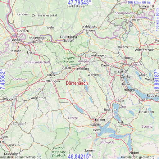
Dürrenäsch GPS coordinates[2]
47° 19' 15.384" North, 8° 9' 31.464" East
| Map corner | latitude | longitude |
|---|---|---|
| Upper-left | 47.79543°, | 7.45562° |
| Center: | 47.32094°, | 8.15874° |
| Lower-right: | 46.84215°, | 8.86187° |
| Map W x H: | 106×106 km | = 65.9×65.9mi |
| max Lat: | 47.76737° ⇑38.9% North |
| Dürrenäsch: | 47.32094° |
| min Lat: | ⇓61.1% South 45.83203° |
| min Long | Dürrenäsch | max Long |
| 5.97153° | 8.15874° | 10.44624° |
| W 43.3%⇐ | ⇒56.7% E |
Elevation
Elevation of Dürrenäsch is 580 m = 1903 ft, and this is 21.8 m = 72 ft above average elevation for this country.
| Max E: |
1845 m = 6053 ft | 29% |
| Dürrenäsch | 580 m 1903 ft | |
| Avg. | 558.2 m = 1831 ft | |
Min E: |
197 m = 646 ft | 71% |
See also: Switzerland elevation on elevation.city.
Geographical zone
Dürrenäsch is located in North temperate zone (between Tropic of Cancer and the Arctic Circle). Distance of this North polar circle is 2139.6 km =1329.5 mi to North.| Distance of | km | miles | from Dürrenäsch |
|---|---|---|---|
| North Pole | 4745.5 | 2948.7 | to North |
| Arctic Circle | 2139.6 | 1329.5 | to North |
| Tropic Cancer | 2655.7 | 1650.2 | to South |
| Equator | 5261.6 | 3269.4 | to South |


Nearby cities:
15 places around Dürrenäsch: (largest is in red/bold)
• Birrwil
4.4 km =2.7 mi,  138°
138°
• Boniswil
2.4 km =1.5 mi,  99°
99°
• Egliswil
3.7 km =2.3 mi,  32°
32°
• Gontenschwil
5.6 km =3.5 mi,  191°
191°
• Gränichen
6 km =3.7 mi,  315°
315°
• Leutwil
1.7 km =1.1 mi, 139°
• Meisterschwanden
6 km =3.7 mi,  118°
118°
• Oberkulm
3.7 km =2.3 mi,  228°
228°
• Schafisheim
6.3 km =3.9 mi,  348°
348°
• Schlossrued
6.2 km =3.9 mi,  238°
238°
• Seengen
3.7 km =2.3 mi,  82°
82°
• Seon
3.1 km =1.9 mi,  2°
2°
• Staufen
6.8 km =4.2 mi,  5°
5°
• Teufenthal
3.2 km =2 mi,  286°
286°
• Unterkulm
3.6 km =2.2 mi,  250°
250°
Sources, notices
• [Note1] Compared only with cities in Switzerland existing in our database
• [Src1] Map data: © OpenStreetMap contributors (CC-BY-SA)
• [Src2] Other city data from geonames.org with taken over terms of usage.
• [Src3] Geographical zone / Annual Mean Temperature by Robert A. Rohde @ Wikipedia
