Birrwil geodata
Birrwil (Aargau) is a populated place; located in Switzerland in Europe/Zurich (GMT+2) time zone. With population of 953 people, there are 1370 cities with bigger population in this country. Compared to other cities in Switzerland, 57% of cities are located further ↓South; 55.5% of cities are located further →East and 58% of cities have lower elevation than Birrwil. Note1


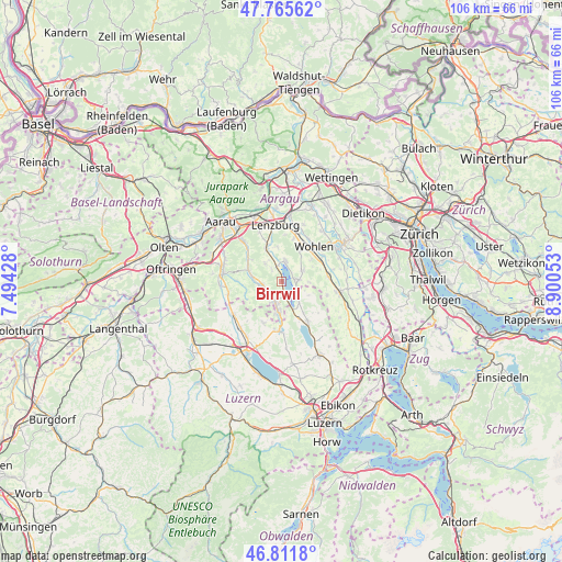
Birrwil GPS coordinates[2]
47° 17' 27.096" North, 8° 11' 50.676" East
| Map corner | latitude | longitude |
|---|---|---|
| Upper-left | 47.76562°, | 7.49428° |
| Center: | 47.29086°, | 8.19741° |
| Lower-right: | 46.8118°, | 8.90053° |
| Map W x H: | 106.1×106.1 km | = 65.9×65.9mi |
| max Lat: | 47.76737° ⇑43% North |
| Birrwil: | 47.29086° |
| min Lat: | ⇓57% South 45.83203° |
| min Long | Birrwil | max Long |
| 5.97153° | 8.19741° | 10.44624° |
| W 44.5%⇐ | ⇒55.5% E |
Elevation
Elevation of Birrwil is 508 m = 1667 ft, and this is 50.2 m = 165 ft below average elevation for this country.
| Max E: |
1845 m = 6053 ft | 42% |
| Avg. | 558.2 m = 1831 ft | |
| Birrwil | 508 m = 1667 ft | |
Min E: |
197 m = 646 ft | 58% |
See also: Switzerland elevation on elevation.city.
Geographical zone
Birrwil is located in North temperate zone (between Tropic of Cancer and the Arctic Circle). Distance of this North polar circle is 2142.9 km =1331.5 mi to North.| Distance of | km | miles | from Birrwil |
|---|---|---|---|
| North Pole | 4748.8 | 2950.8 | to North |
| Arctic Circle | 2142.9 | 1331.5 | to North |
| Tropic Cancer | 2652.3 | 1648.1 | to South |
| Equator | 5258.3 | 3267.4 | to South |


Nearby cities:
15 places around Birrwil: (largest is in red/bold)
• Aesch
5 km =3.1 mi,  139°
139°
• Beinwil
3.4 km =2.1 mi,  170°
170°
• Boniswil
3 km =1.9 mi,  348°
348°
• Dürrenäsch
4.4 km =2.7 mi,  318°
318°
• Egliswil
6.6 km =4.1 mi, 352°
• Gontenschwil
4.6 km =2.9 mi,  242°
242°
• Leutwil
2.8 km =1.7 mi, 318°
• Meisterschwanden
2.4 km =1.5 mi,  79°
79°
• Menziken
5.7 km =3.5 mi,  185°
185°
• Oberkulm
5.7 km =3.5 mi,  279°
279°
• Pfeffikon
5 km =3.1 mi,  197°
197°
• Reinach
3.9 km =2.4 mi, 198°
• Sarmenstorf
4.5 km =2.8 mi,  60°
60°
• Seengen
3.9 km =2.4 mi,  11°
11°
• Unterkulm
6.7 km =4.2 mi,  288°
288°
Sources, notices
• [Note1] Compared only with cities in Switzerland existing in our database
• [Src1] Map data: © OpenStreetMap contributors (CC-BY-SA)
• [Src2] Other city data from geonames.org with taken over terms of usage.
• [Src3] Geographical zone / Annual Mean Temperature by Robert A. Rohde @ Wikipedia
