Pfäffikon geodata
Pfäffikon (Schwyz) is a populated place; located in Switzerland in Europe/Zurich (GMT+2) time zone. With population of 7,310 people, there are 224 cities with bigger population in this country. Compared to other cities in Switzerland, 52.6% of cities are located further ↑North; 80.1% of cities are located further ←West and 80.6% of cities have higher elevation than Pfäffikon. Note1


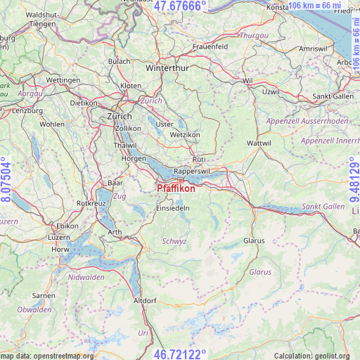
Pfäffikon GPS coordinates[2]
47° 12' 3.924" North, 8° 46' 41.376" East
| Map corner | latitude | longitude |
|---|---|---|
| Upper-left | 47.67666°, | 8.07504° |
| Center: | 47.20109°, | 8.77816° |
| Lower-right: | 46.72122°, | 9.48129° |
| Map W x H: | 106.2×106.2 km | = 66×66mi |
| max Lat: | 47.76737° ⇑52.6% North |
| Pfäffikon: | 47.20109° |
| min Lat: | ⇓47.4% South 45.83203° |
| min Long | Pfäffikon | max Long |
| 5.97153° | 8.77816° | 10.44624° |
| W 80.1%⇐ | ⇒19.9% E |
Elevation
Elevation of Pfäffikon is 420 m = 1378 ft, and this is 138.2 m = 453 ft below average elevation for this country.
| Max E: |
1845 m = 6053 ft | 80.6% |
| Avg. | 558.2 m = 1831 ft | |
| Pfäffikon | 420 m = 1378 ft | |
Min E: |
197 m = 646 ft | 19.4% |
See also: Switzerland elevation on elevation.city.
Geographical zone
Pfäffikon is located in North temperate zone (between Tropic of Cancer and the Arctic Circle). Distance of this North polar circle is 2152.9 km =1337.7 mi to North.| Distance of | km | miles | from Pfäffikon |
|---|---|---|---|
| North Pole | 4758.8 | 2957 | to North |
| Arctic Circle | 2152.9 | 1337.7 | to North |
| Tropic Cancer | 2642.4 | 1641.9 | to South |
| Equator | 5248.3 | 3261.1 | to South |


Nearby cities:
15 places around Pfäffikon: (largest is in red/bold)
• Altendorf
4.7 km =2.9 mi,  105°
105°
• Bäch
3.5 km =2.2 mi,  275°
275°
• Dorf
5.3 km =3.3 mi,  322°
322°
• Feusisberg
2.8 km =1.7 mi,  236°
236°
• Freienbach
1.6 km =1 mi,  287°
287°
• Hombrechtikon / Eichberg
5.4 km =3.4 mi,  355°
355°
• Hombrechtikon / Grossacher
5.6 km =3.5 mi, 359°
• Jona
5.6 km =3.5 mi,  55°
55°
• Kehlhof
4.8 km =3 mi, 321°
• Rapperswil
4.3 km =2.7 mi,  50°
50°
• Richterswil / Dorfkern
5.5 km =3.4 mi, 277°
• Richterswil / Richterswil (Dorfkern)
5.5 km =3.4 mi,  272°
272°
• Schindellegi
5.7 km =3.5 mi, 238°
• Uerikon
4.3 km =2.7 mi,  338°
338°
• Wollerau
4.5 km =2.8 mi,  261°
261°
Sources, notices
• [Note1] Compared only with cities in Switzerland existing in our database
• [Src1] Map data: © OpenStreetMap contributors (CC-BY-SA)
• [Src2] Other city data from geonames.org with taken over terms of usage.
• [Src3] Geographical zone / Annual Mean Temperature by Robert A. Rohde @ Wikipedia
