Richterswil / Dorfkern geodata
Richterswil / Dorfkern (Zurich) is a section of populated place; located in Switzerland in Europe/Zurich (GMT+2) time zone. With population of 1,216 people, there are 1186 cities with bigger population in this country. Compared to other cities in Switzerland, 52% of cities are located further ↑North; 74.7% of cities are located further ←West and 83.4% of cities have higher elevation than Richterswil / Dorfkern. Note1
Current local time in Richterswil / Dorfkern:
06:19 AM, SaturdayDifference from your time zone: hours


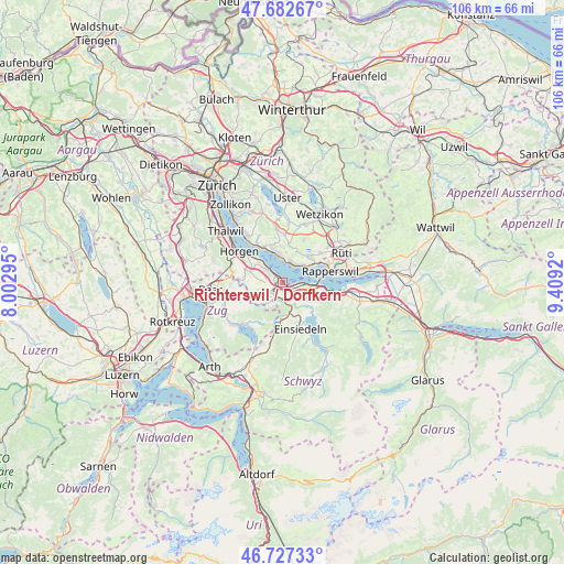
Richterswil / Dorfkern GPS coordinates[2]
47° 12' 25.74" North, 8° 42' 21.852" East
| Map corner | latitude | longitude |
|---|---|---|
| Upper-left | 47.68267°, | 8.00295° |
| Center: | 47.20715°, | 8.70607° |
| Lower-right: | 46.72733°, | 9.4092° |
| Map W x H: | 106.2×106.2 km | = 66×66mi |
| max Lat: | 47.76737° ⇑52% North |
| Richterswil / Dorfkern: | 47.20715° |
| min Lat: | ⇓48% South 45.83203° |
| min Long | Richterswil / D | max Long |
| 5.97153° | 8.70607° | 10.44624° |
| W 74.7%⇐ | ⇒25.3% E |
Elevation
Elevation of Richterswil / Dorfkern is 414 m = 1358 ft, and this is 144.2 m = 473 ft below average elevation for this country.
| Max E: |
1845 m = 6053 ft | 83.4% |
| Avg. | 558.2 m = 1831 ft | |
| Richterswil / Dorfkern | 414 m = 1358 ft | |
Min E: |
197 m = 646 ft | 16.6% |
See also: Switzerland elevation on elevation.city.
Geographical zone
Richterswil / Dorfkern is located in North temperate zone (between Tropic of Cancer and the Arctic Circle). Distance of this North polar circle is 2152.2 km =1337.3 mi to North.| Distance of | km | miles | from Richterswil / Dorfkern |
|---|---|---|---|
| North Pole | 4758.1 | 2956.5 | to North |
| Arctic Circle | 2152.2 | 1337.3 | to North |
| Tropic Cancer | 2643 | 1642.3 | to South |
| Equator | 5248.9 | 3261.5 | to South |


Nearby cities:
15 places around Richterswil / Dorfkern: (largest is in red/bold)
• Bäch
2 km =1.2 mi,  100°
100°
• Feusisberg
3.8 km =2.4 mi,  125°
125°
• Freienbach
4 km =2.5 mi,  92°
92°
• Kehlhof
3.9 km =2.4 mi,  38°
38°
• Richterswil
0.7 km =0.4 mi,  261°
261°
• Richterswil / Burghalde
1.1 km =0.7 mi,  284°
284°
• Richterswil / Richterswil (Dorfkern)
0.4 km =0.2 mi,  188°
188°
• Samstagern
2.5 km =1.6 mi,  226°
226°
• Schindellegi
3.7 km =2.3 mi,  171°
171°
• Wollerau
1.7 km =1.1 mi,  144°
144°
• Wädenswil
3.6 km =2.2 mi,  307°
307°
• Wädenswil / Boller-Giessen
2.3 km =1.4 mi, 312°
• Wädenswil / Dorf (Wädenswil)
3.5 km =2.2 mi, 313°
• Wädenswil / Eichweid
2.7 km =1.7 mi,  297°
297°
• Wädenswil / Leihof-Mühlebach
3.2 km =2 mi, 305°
Sources, notices
• [Note1] Compared only with cities in Switzerland existing in our database
• [Src1] Map data: © OpenStreetMap contributors (CC-BY-SA)
• [Src2] Other city data from geonames.org with taken over terms of usage.
• [Src3] Geographical zone / Annual Mean Temperature by Robert A. Rohde @ Wikipedia
