Wetzikon / Ober-Wetzikon geodata
Wetzikon / Ober-Wetzikon (Zurich) is a section of populated place; located in Switzerland in Europe/Zurich (GMT+2) time zone. With population of 3,858 people, there are 463 cities with bigger population in this country. Compared to other cities in Switzerland, 61.7% of cities are located further ↓South; 81.3% of cities are located further ←West and 64.8% of cities have lower elevation than Wetzikon / Ober-Wetzikon. Note1
Current local time in Wetzikon / Ober-Wetzikon:
07:40 AM, SaturdayDifference from your time zone: hours


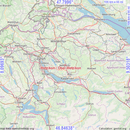
Wetzikon / Ober-Wetzikon GPS coordinates[2]
47° 19' 30.504" North, 8° 48' 0.18" East
| Map corner | latitude | longitude |
|---|---|---|
| Upper-left | 47.7996°, | 8.09693° |
| Center: | 47.32514°, | 8.80005° |
| Lower-right: | 46.84638°, | 9.50318° |
| Map W x H: | 106×106 km | = 65.9×65.9mi |
| max Lat: | 47.76737° ⇑38.3% North |
| Wetzikon / Ober-Wetzikon: | 47.32514° |
| min Lat: | ⇓61.7% South 45.83203° |
| min Long | Wetzikon / Ober | max Long |
| 5.97153° | 8.80005° | 10.44624° |
| W 81.3%⇐ | ⇒18.7% E |
Elevation
Elevation of Wetzikon / Ober-Wetzikon is 545 m = 1788 ft, and this is 13.2 m = 43 ft below average elevation for this country.
| Max E: |
1845 m = 6053 ft | 35.2% |
| Avg. | 558.2 m = 1831 ft | |
| Wetzikon / Ober-Wetzikon | 545 m = 1788 ft | |
Min E: |
197 m = 646 ft | 64.8% |
See also: Switzerland elevation on elevation.city.
Geographical zone
Wetzikon / Ober-Wetzikon is located in North temperate zone (between Tropic of Cancer and the Arctic Circle). Distance of this North polar circle is 2139.1 km =1329.2 mi to North.| Distance of | km | miles | from Wetzikon / Ober-Wetzikon |
|---|---|---|---|
| North Pole | 4745 | 2948.4 | to North |
| Arctic Circle | 2139.1 | 1329.2 | to North |
| Tropic Cancer | 2656.1 | 1650.4 | to South |
| Equator | 5262.1 | 3269.7 | to South |


Nearby cities:
15 places around Wetzikon / Ober-Wetzikon: (largest is in red/bold)
• Adetswil
3.4 km =2.1 mi,  61°
61°
• Bertschikon
3.2 km =2 mi,  260°
260°
• Bäretswil
4.5 km =2.8 mi,  72°
72°
• Gossau
3.9 km =2.4 mi,  234°
234°
• Grüt
2 km =1.2 mi,  219°
219°
• Oberhittnau
4.1 km =2.5 mi,  25°
25°
• Oberkempten
1.6 km =1 mi,  76°
76°
• Pfäffikon
4.4 km =2.7 mi,  352°
352°
• Pfäffikon / Irgenhausen
4.2 km =2.6 mi, 352°
• Weid (bei Adetswil)
4.1 km =2.5 mi, 65°
• Wetzikon
0.2 km =0.1 mi,  309°
309°
• Wetzikon / Kempten
1.2 km =0.7 mi,  39°
39°
• Wetzikon / Robenhausen
1.1 km =0.7 mi,  304°
304°
• Wetzikon / Unter-Wetzikon
1.1 km =0.7 mi,  206°
206°
• Widum
0.7 km =0.4 mi, 298°
Sources, notices
• [Note1] Compared only with cities in Switzerland existing in our database
• [Src1] Map data: © OpenStreetMap contributors (CC-BY-SA)
• [Src2] Other city data from geonames.org with taken over terms of usage.
• [Src3] Geographical zone / Annual Mean Temperature by Robert A. Rohde @ Wikipedia
