Pfäffikon / Irgenhausen geodata
Pfäffikon / Irgenhausen (Zurich) is a section of populated place; located in Switzerland in Europe/Zurich (GMT+2) time zone. With population of 2,032 people, there are 825 cities with bigger population in this country. Compared to other cities in Switzerland, 66.2% of cities are located further ↓South; 80.8% of cities are located further ←West and 67% of cities have lower elevation than Pfäffikon / Irgenhausen. Note1
Current local time in Pfäffikon / Irgenhausen:
07:40 AM, SaturdayDifference from your time zone: hours


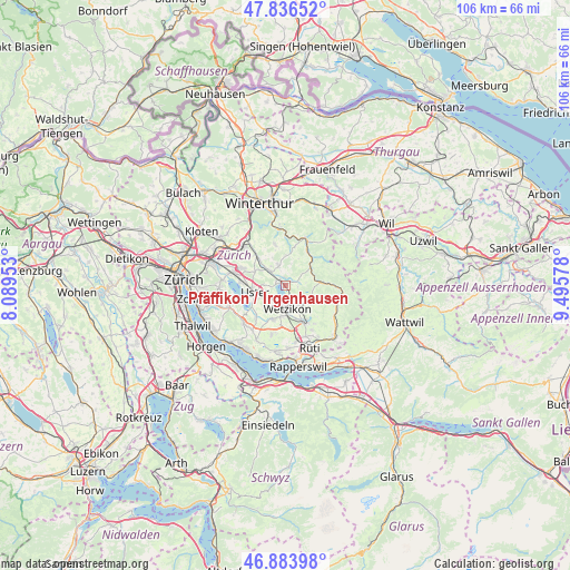
Pfäffikon / Irgenhausen GPS coordinates[2]
47° 21' 44.64" North, 8° 47' 33.54" East
| Map corner | latitude | longitude |
|---|---|---|
| Upper-left | 47.83652°, | 8.08953° |
| Center: | 47.3624°, | 8.79265° |
| Lower-right: | 46.88398°, | 9.49578° |
| Map W x H: | 105.9×105.9 km | = 65.8×65.8mi |
| max Lat: | 47.76737° ⇑33.8% North |
| Pfäffikon / Irgenhausen: | 47.3624° |
| min Lat: | ⇓66.2% South 45.83203° |
| min Long | Pfäffikon / Ir | max Long |
| 5.97153° | 8.79265° | 10.44624° |
| W 80.8%⇐ | ⇒19.2% E |
Elevation
Elevation of Pfäffikon / Irgenhausen is 557 m = 1827 ft, and this is 1.2 m = 4 ft below average elevation for this country.
| Max E: |
1845 m = 6053 ft | 33% |
| Avg. | 558.2 m = 1831 ft | |
| Pfäffikon / Irgenhausen | 557 m = 1827 ft | |
Min E: |
197 m = 646 ft | 67% |
See also: Switzerland elevation on elevation.city.
Geographical zone
Pfäffikon / Irgenhausen is located in North temperate zone (between Tropic of Cancer and the Arctic Circle). Distance of this North polar circle is 2135 km =1326.6 mi to North.| Distance of | km | miles | from Pfäffikon / Irgenhausen |
|---|---|---|---|
| North Pole | 4740.9 | 2945.9 | to North |
| Arctic Circle | 2135 | 1326.6 | to North |
| Tropic Cancer | 2660.3 | 1653 | to South |
| Equator | 5266.2 | 3272.3 | to South |


Nearby cities:
15 places around Pfäffikon / Irgenhausen: (largest is in red/bold)
• Adetswil
4.4 km =2.7 mi,  125°
125°
• Fehraltorf
4.2 km =2.6 mi,  312°
312°
• Hittnau / Hittnau (Dorf)
2.4 km =1.5 mi,  87°
87°
• Oberhittnau
2.4 km =1.5 mi,  100°
100°
• Oberkempten
4.3 km =2.7 mi,  150°
150°
• Pfäffikon
0.2 km =0.1 mi,  348°
348°
• Pfäffikon / Pfäffikon (Dorfkern)
1.1 km =0.7 mi,  317°
317°
• Russikon
4 km =2.5 mi,  340°
340°
• Uster / Ober-Uster
4.7 km =2.9 mi,  251°
251°
• Wermatswil
3.9 km =2.4 mi,  272°
272°
• Wetzikon
4 km =2.5 mi,  174°
174°
• Wetzikon / Kempten
3.5 km =2.2 mi,  158°
158°
• Wetzikon / Ober-Wetzikon
4.2 km =2.6 mi, 172°
• Wetzikon / Robenhausen
3.5 km =2.2 mi,  186°
186°
• Widum
3.8 km =2.4 mi,  180°
180°
Sources, notices
• [Note1] Compared only with cities in Switzerland existing in our database
• [Src1] Map data: © OpenStreetMap contributors (CC-BY-SA)
• [Src2] Other city data from geonames.org with taken over terms of usage.
• [Src3] Geographical zone / Annual Mean Temperature by Robert A. Rohde @ Wikipedia
