Männedorf geodata
Männedorf (Zurich) is a seat of a third-order administrative division; located in Switzerland in Europe/Zurich (GMT+2) time zone. With population of 7,951 people, there are 203 cities with bigger population in this country. Compared to other cities in Switzerland, 52.6% of cities are located further ↓South; 74.1% of cities are located further ←West and 57.6% of cities have higher elevation than Männedorf. Note1


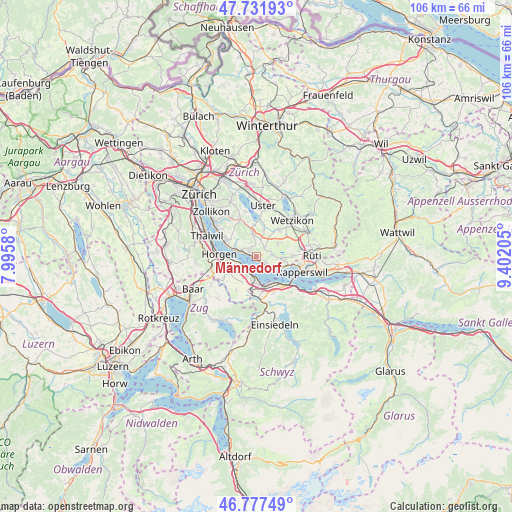
Männedorf GPS coordinates[2]
47° 15' 24.696" North, 8° 41' 56.148" East
| Map corner | latitude | longitude |
|---|---|---|
| Upper-left | 47.73193°, | 7.9958° |
| Center: | 47.25686°, | 8.69893° |
| Lower-right: | 46.77749°, | 9.40205° |
| Map W x H: | 106.1×106.1 km | = 65.9×65.9mi |
| max Lat: | 47.76737° ⇑47.4% North |
| Männedorf: | 47.25686° |
| min Lat: | ⇓52.6% South 45.83203° |
| min Long | Männedorf | max Long |
| 5.97153° | 8.69893° | 10.44624° |
| W 74.1%⇐ | ⇒25.9% E |
Elevation
Elevation of Männedorf is 460 m = 1509 ft, and this is 98.2 m = 322 ft below average elevation for this country.
| Max E: |
1845 m = 6053 ft | 57.6% |
| Avg. | 558.2 m = 1831 ft | |
| Männedorf | 460 m = 1509 ft | |
Min E: |
197 m = 646 ft | 42.4% |
See also: Switzerland elevation on elevation.city.
Geographical zone
Männedorf is located in North temperate zone (between Tropic of Cancer and the Arctic Circle). Distance of this North polar circle is 2146.7 km =1333.9 mi to North.| Distance of | km | miles | from Männedorf |
|---|---|---|---|
| North Pole | 4752.6 | 2953.1 | to North |
| Arctic Circle | 2146.7 | 1333.9 | to North |
| Tropic Cancer | 2648.6 | 1645.8 | to South |
| Equator | 5254.5 | 3265 | to South |


Nearby cities:
15 places around Männedorf: (largest is in red/bold)
• Dorf
3.4 km =2.1 mi,  125°
125°
• Esslingen
3.1 km =1.9 mi,  16°
16°
• Meilen / Halten
3.5 km =2.2 mi,  295°
295°
• Männedorf / Ausserfeld
1.3 km =0.8 mi,  155°
155°
• Männedorf / Dorfkern
0.6 km =0.4 mi,  261°
261°
• Obermeilen
3.4 km =2.1 mi,  286°
286°
• Oetwil
2.2 km =1.4 mi,  46°
46°
• Oetwil / Vogelsang
2.4 km =1.5 mi,  64°
64°
• Oetwil / Zelgliacker
2.5 km =1.6 mi,  41°
41°
• Stäfa
2.4 km =1.5 mi, 130°
• Uetikon
1.7 km =1.1 mi, 299°
• Uetikon / Chlidorf
1.4 km =0.9 mi,  305°
305°
• Uetikon / Grossdorf
1.9 km =1.2 mi, 303°
• Wädenswil / Büelen
3.7 km =2.3 mi,  226°
226°
• Wädenswil / Dorf (Wädenswil)
3.7 km =2.3 mi,  213°
213°
Sources, notices
• [Note1] Compared only with cities in Switzerland existing in our database
• [Src1] Map data: © OpenStreetMap contributors (CC-BY-SA)
• [Src2] Other city data from geonames.org with taken over terms of usage.
• [Src3] Geographical zone / Annual Mean Temperature by Robert A. Rohde @ Wikipedia
