Männedorf / Dorfkern geodata
Männedorf / Dorfkern (Zurich) is a section of populated place; located in Switzerland in Europe/Zurich (GMT+2) time zone. With population of 4,893 people, there are 352 cities with bigger population in this country. Compared to other cities in Switzerland, 52.4% of cities are located further ↓South; 73.7% of cities are located further ←West and 78.4% of cities have higher elevation than Männedorf / Dorfkern. Note1


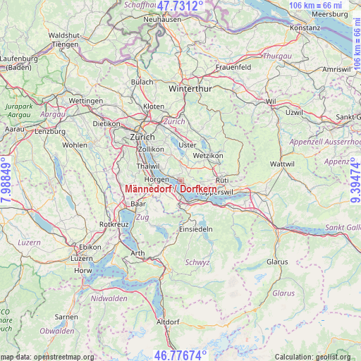
Männedorf / Dorfkern GPS coordinates[2]
47° 15' 22.032" North, 8° 41' 29.796" East
| Map corner | latitude | longitude |
|---|---|---|
| Upper-left | 47.7312°, | 7.98849° |
| Center: | 47.25612°, | 8.69161° |
| Lower-right: | 46.77674°, | 9.39474° |
| Map W x H: | 106.1×106.1 km | = 65.9×65.9mi |
| max Lat: | 47.76737° ⇑47.6% North |
| Männedorf / Dorfkern: | 47.25612° |
| min Lat: | ⇓52.4% South 45.83203° |
| min Long | Männedorf / Do | max Long |
| 5.97153° | 8.69161° | 10.44624° |
| W 73.7%⇐ | ⇒26.3% E |
Elevation
Elevation of Männedorf / Dorfkern is 425 m = 1394 ft, and this is 133.2 m = 437 ft below average elevation for this country.
| Max E: |
1845 m = 6053 ft | 78.4% |
| Avg. | 558.2 m = 1831 ft | |
| Männedorf / Dorfkern | 425 m = 1394 ft | |
Min E: |
197 m = 646 ft | 21.6% |
See also: Switzerland elevation on elevation.city.
Geographical zone
Männedorf / Dorfkern is located in North temperate zone (between Tropic of Cancer and the Arctic Circle). Distance of this North polar circle is 2146.8 km =1334 mi to North.| Distance of | km | miles | from Männedorf / Dorfkern |
|---|---|---|---|
| North Pole | 4752.7 | 2953.2 | to North |
| Arctic Circle | 2146.8 | 1334 | to North |
| Tropic Cancer | 2648.5 | 1645.7 | to South |
| Equator | 5254.4 | 3264.9 | to South |


Nearby cities:
15 places around Männedorf / Dorfkern: (largest is in red/bold)
• Au / Ober-Ort/Gwad
3.2 km =2 mi,  234°
234°
• Esslingen
3.3 km =2.1 mi,  25°
25°
• Meilen / Halten
3.1 km =1.9 mi,  301°
301°
• Männedorf
0.6 km =0.4 mi,  81°
81°
• Männedorf / Ausserfeld
1.5 km =0.9 mi,  134°
134°
• Obermeilen
2.9 km =1.8 mi,  291°
291°
• Oetwil
2.7 km =1.7 mi,  53°
53°
• Oetwil / Vogelsang
2.9 km =1.8 mi,  67°
67°
• Oetwil / Zelgliacker
2.9 km =1.8 mi, 48°
• Stäfa
2.8 km =1.7 mi,  122°
122°
• Uetikon
1.3 km =0.8 mi,  314°
314°
• Uetikon / Chlidorf
1.1 km =0.7 mi,  325°
325°
• Uetikon / Grossdorf
1.6 km =1 mi,  317°
317°
• Wädenswil / Büelen
3.3 km =2.1 mi,  220°
220°
• Wädenswil / Dorf (Wädenswil)
3.3 km =2.1 mi,  206°
206°
Sources, notices
• [Note1] Compared only with cities in Switzerland existing in our database
• [Src1] Map data: © OpenStreetMap contributors (CC-BY-SA)
• [Src2] Other city data from geonames.org with taken over terms of usage.
• [Src3] Geographical zone / Annual Mean Temperature by Robert A. Rohde @ Wikipedia
