Linthal geodata
Linthal (Glarus) is a populated place; located in Switzerland in Europe/Zurich (GMT+2) time zone. With population of 1,080 people, there are 1274 cities with bigger population in this country. Compared to other cities in Switzerland, 68.4% of cities are located further ↑North; 88.2% of cities are located further ←West and 79.2% of cities have lower elevation than Linthal. Note1


Linthal GPS coordinates[2]
46° 55' 16.572" North, 8° 59' 52.764" East
| Map corner | latitude | longitude |
|---|---|---|
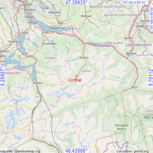
| Upper-left | 47.39935°, | 8.29487° |
| Center: | 46.92127°, | 8.99799° |
| Lower-right: | 46.43888°, | 9.70112° |
| Map W x H: | 106.8×106.8 km | = 66.4×66.4mi |
| max Lat: | 47.76737° ⇑68.4% North |
| Linthal: | 46.92127° |
| min Lat: | ⇓31.6% South 45.83203° |
| min Long | Linthal | max Long |
| 5.97153° | 8.99799° | 10.44624° |
| W 88.2%⇐ | ⇒11.8% E |
Elevation
Elevation of Linthal is 652 m = 2139 ft, and this is 93.8 m = 308 ft above average elevation for this country.
| Max E: |
1845 m = 6053 ft | 20.8% |
| Linthal | 652 m 2139 ft | |
| Avg. | 558.2 m = 1831 ft | |
Min E: |
197 m = 646 ft | 79.2% |
See also: Switzerland elevation on elevation.city.
Geographical zone
Linthal is located in North temperate zone (between Tropic of Cancer and the Arctic Circle). Distance of this North polar circle is 2184 km =1357.1 mi to North.| Distance of | km | miles | from Linthal |
|---|---|---|---|
| North Pole | 4789.9 | 2976.3 | to North |
| Arctic Circle | 2184 | 1357.1 | to North |
| Tropic Cancer | 2611.2 | 1622.5 | to South |
| Equator | 5217.2 | 3241.8 | to South |


Nearby cities:
15 places around Linthal: (largest is in red/bold)
• Breíl
17.5 km =10.9 mi,  164°
164°
• Elm
13.2 km =8.2 mi,  91°
91°
• Engi
13.5 km =8.4 mi,  60°
60°
• Ennenda
13.9 km =8.6 mi,  26°
26°
• Glarus
14.3 km =8.9 mi,  21°
21°
• Luchsingen
5.8 km =3.6 mi, 30°
• Mollis
19.5 km =12.1 mi, 16°
• Muotathal
18.7 km =11.6 mi,  289°
289°
• Netstal
16.4 km =10.2 mi, 15°
• Näfels
20.2 km =12.6 mi,  14°
14°
• Obersaxen
20.6 km =12.8 mi, 157°
• Rueun
19.6 km =12.2 mi,  144°
144°
• Schwanden
9.9 km =6.2 mi, 33°
• Trun
19.8 km =12.3 mi,  182°
182°
• Unterschächen
18.6 km =11.6 mi,  249°
249°
Sources, notices
• [Note1] Compared only with cities in Switzerland existing in our database
• [Src1] Map data: © OpenStreetMap contributors (CC-BY-SA)
• [Src2] Other city data from geonames.org with taken over terms of usage.
• [Src3] Geographical zone / Annual Mean Temperature by Robert A. Rohde @ Wikipedia
