Ennenda geodata
Ennenda (Glarus) is a populated place; located in Switzerland in Europe/Zurich (GMT+2) time zone. With population of 2,699 people, there are 656 cities with bigger population in this country. Compared to other cities in Switzerland, 62.6% of cities are located further ↑North; 90.5% of cities are located further ←West and 50.8% of cities have lower elevation than Ennenda. Note1


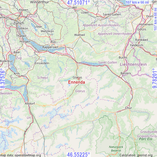
Ennenda GPS coordinates[2]
47° 2' 1.068" North, 9° 4' 43.968" East
| Map corner | latitude | longitude |
|---|---|---|
| Upper-left | 47.51071°, | 8.37576° |
| Center: | 47.03363°, | 9.07888° |
| Lower-right: | 46.55225°, | 9.78201° |
| Map W x H: | 106.6×106.6 km | = 66.2×66.2mi |
| max Lat: | 47.76737° ⇑62.6% North |
| Ennenda: | 47.03363° |
| min Lat: | ⇓37.4% South 45.83203° |
| min Long | Ennenda | max Long |
| 5.97153° | 9.07888° | 10.44624° |
| W 90.5%⇐ | ⇒9.5% E |
Elevation
Elevation of Ennenda is 479 m = 1572 ft, and this is 79.2 m = 260 ft below average elevation for this country.
| Max E: |
1845 m = 6053 ft | 49.2% |
| Avg. | 558.2 m = 1831 ft | |
| Ennenda | 479 m = 1572 ft | |
Min E: |
197 m = 646 ft | 50.8% |
See also: Switzerland elevation on elevation.city.
Geographical zone
Ennenda is located in North temperate zone (between Tropic of Cancer and the Arctic Circle). Distance of this North polar circle is 2171.5 km =1349.3 mi to North.| Distance of | km | miles | from Ennenda |
|---|---|---|---|
| North Pole | 4777.4 | 2968.5 | to North |
| Arctic Circle | 2171.5 | 1349.3 | to North |
| Tropic Cancer | 2623.7 | 1630.3 | to South |
| Equator | 5229.6 | 3249.5 | to South |


Nearby cities:
15 places around Ennenda: (largest is in red/bold)
• Amden
13.7 km =8.5 mi,  20°
20°
• Bilten
13.5 km =8.4 mi,  342°
342°
• Engi
8 km =5 mi,  135°
135°
• Filzbach
10.3 km =6.4 mi, 23°
• Glarus
1.1 km =0.7 mi,  313°
313°
• Linthal
13.9 km =8.6 mi,  206°
206°
• Luchsingen
8.1 km =5 mi,  202°
202°
• Mollis
6.2 km =3.9 mi,  355°
355°
• Netstal
3.7 km =2.3 mi,  333°
333°
• Niederurnen
10.4 km =6.5 mi,  349°
349°
• Näfels
7.2 km =4.5 mi, 350°
• Oberurnen
9.1 km =5.7 mi, 350°
• Schwanden
4.3 km =2.7 mi,  188°
188°
• Schänis
14.3 km =8.9 mi, 349°
• Weesen
11.3 km =7 mi,  6°
6°
Sources, notices
• [Note1] Compared only with cities in Switzerland existing in our database
• [Src1] Map data: © OpenStreetMap contributors (CC-BY-SA)
• [Src2] Other city data from geonames.org with taken over terms of usage.
• [Src3] Geographical zone / Annual Mean Temperature by Robert A. Rohde @ Wikipedia
