Muotathal geodata
Muotathal (Schwyz) is a populated place; located in Switzerland in Europe/Zurich (GMT+2) time zone. With population of 3,548 people, there are 500 cities with bigger population in this country. Compared to other cities in Switzerland, 65.6% of cities are located further ↑North; 79.1% of cities are located further ←West and 77.8% of cities have lower elevation than Muotathal. Note1


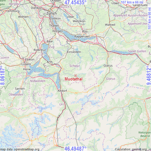
Muotathal GPS coordinates[2]
46° 58' 36.336" North, 8° 45' 53.964" East
| Map corner | latitude | longitude |
|---|---|---|
| Upper-left | 47.45435°, | 8.06187° |
| Center: | 46.97676°, | 8.76499° |
| Lower-right: | 46.49487°, | 9.46812° |
| Map W x H: | 106.7×106.7 km | = 66.3×66.3mi |
| max Lat: | 47.76737° ⇑65.6% North |
| Muotathal: | 46.97676° |
| min Lat: | ⇓34.4% South 45.83203° |
| min Long | Muotathal | max Long |
| 5.97153° | 8.76499° | 10.44624° |
| W 79.1%⇐ | ⇒20.9% E |
Elevation
Elevation of Muotathal is 640 m = 2100 ft, and this is 81.8 m = 268 ft above average elevation for this country.
| Max E: |
1845 m = 6053 ft | 22.2% |
| Muotathal | 640 m 2100 ft | |
| Avg. | 558.2 m = 1831 ft | |
Min E: |
197 m = 646 ft | 77.8% |
See also: Switzerland elevation on elevation.city.
Geographical zone
Muotathal is located in North temperate zone (between Tropic of Cancer and the Arctic Circle). Distance of this North polar circle is 2177.8 km =1353.2 mi to North.| Distance of | km | miles | from Muotathal |
|---|---|---|---|
| North Pole | 4783.7 | 2972.5 | to North |
| Arctic Circle | 2177.8 | 1353.2 | to North |
| Tropic Cancer | 2617.4 | 1626.4 | to South |
| Equator | 5223.3 | 3245.6 | to South |


Nearby cities:
15 places around Muotathal: (largest is in red/bold)
• Alpthal
11 km =6.8 mi,  340°
340°
• Altdorf
14.1 km =8.8 mi,  220°
220°
• Bürglen
13.5 km =8.4 mi,  213°
213°
• Flüelen
13.4 km =8.3 mi,  233°
233°
• Ibach
9.8 km =6.1 mi,  292°
292°
• Illgau
3.3 km =2.1 mi, 291°
• Ingenbohl
11.6 km =7.2 mi,  282°
282°
• Morschach
11.2 km =7 mi,  273°
273°
• Oberiberg
6.9 km =4.3 mi,  8°
8°
• Schwyz
9.7 km =6 mi,  300°
300°
• Seelisberg
13.5 km =8.4 mi, 268°
• Spiringen
11.9 km =7.4 mi,  192°
192°
• Steinen
14.1 km =8.8 mi,  305°
305°
• Unteriberg
10 km =6.2 mi,  17°
17°
• Unterschächen
12.7 km =7.9 mi,  178°
178°
Sources, notices
• [Note1] Compared only with cities in Switzerland existing in our database
• [Src1] Map data: © OpenStreetMap contributors (CC-BY-SA)
• [Src2] Other city data from geonames.org with taken over terms of usage.
• [Src3] Geographical zone / Annual Mean Temperature by Robert A. Rohde @ Wikipedia
