Le Chenit geodata
Le Chenit (Vaud) is a populated place; located in Switzerland in Europe/Zurich (GMT+2) time zone. With population of 4,062 people, there are 429 cities with bigger population in this country. Compared to other cities in Switzerland, 82.2% of cities are located further ↑North; 97.9% of cities are located further →East and 95.3% of cities have lower elevation than Le Chenit. Note1


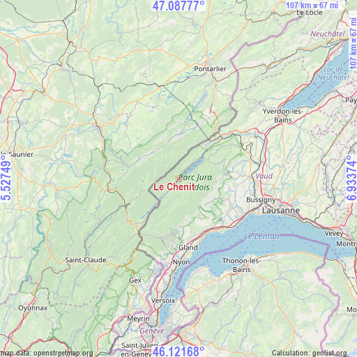
Le Chenit GPS coordinates[2]
46° 36' 24.768" North, 6° 13' 50.232" East
| Map corner | latitude | longitude |
|---|---|---|
| Upper-left | 47.08777°, | 5.52749° |
| Center: | 46.60688°, | 6.23062° |
| Lower-right: | 46.12168°, | 6.93374° |
| Map W x H: | 107.4×107.4 km | = 66.7×66.7mi |
| max Lat: | 47.76737° ⇑82.2% North |
| Le Chenit: | 46.60688° |
| min Lat: | ⇓17.8% South 45.83203° |
| min Long | Le Chenit | max Long |
| 5.97153° | 6.23062° | 10.44624° |
| W 2.1%⇐ | ⇒97.9% E |
Elevation
Elevation of Le Chenit is 1015 m = 3330 ft, and this is 456.8 m = 1499 ft above average elevation for this country.
| Max E: |
1845 m = 6053 ft | 4.7% |
| Le Chenit | 1015 m 3330 ft | |
| Avg. | 558.2 m = 1831 ft | |
Min E: |
197 m = 646 ft | 95.3% |
See also: Switzerland elevation on elevation.city.
Geographical zone
Le Chenit is located in North temperate zone (between Tropic of Cancer and the Arctic Circle). Distance of this North polar circle is 2219 km =1378.8 mi to North.| Distance of | km | miles | from Le Chenit |
|---|---|---|---|
| North Pole | 4824.9 | 2998.1 | to North |
| Arctic Circle | 2219 | 1378.8 | to North |
| Tropic Cancer | 2576.3 | 1600.8 | to South |
| Equator | 5182.2 | 3220.1 | to South |


Nearby cities:
15 places around Le Chenit: (largest is in red/bold)
• Apples
16.3 km =10.1 mi,  111°
111°
• Ballens
12.3 km =7.6 mi,  117°
117°
• Berolle
9.7 km =6 mi, 124°
• Bière
11 km =6.8 mi,  134°
134°
• Cuarnens
15.9 km =9.9 mi,  82°
82°
• Gimel
12.3 km =7.6 mi,  151°
151°
• L'Abbaye
8.3 km =5.2 mi,  54°
54°
• Le Vaud
14.4 km =8.9 mi,  178°
178°
• Mauraz
14.5 km =9 mi,  90°
90°
• Mollens
10.6 km =6.6 mi, 107°
• Montricher
11.2 km =7 mi, 94°
• Pampigny
15.5 km =9.6 mi,  100°
100°
• Saint-George
10.5 km =6.5 mi,  167°
167°
• Saubraz
12.6 km =7.8 mi,  142°
142°
• Vallorbe
16.3 km =10.1 mi,  43°
43°
Sources, notices
• [Note1] Compared only with cities in Switzerland existing in our database
• [Src1] Map data: © OpenStreetMap contributors (CC-BY-SA)
• [Src2] Other city data from geonames.org with taken over terms of usage.
• [Src3] Geographical zone / Annual Mean Temperature by Robert A. Rohde @ Wikipedia
