L'Abbaye geodata
L'Abbaye (Vaud) is a seat of a third-order administrative division; located in Switzerland in Europe/Zurich (GMT+2) time zone. In our database, there are 1823 cities with bigger population. Compared to other cities in Switzerland, 80.6% of cities are located further ↑North; 97.1% of cities are located further →East and 95.1% of cities have lower elevation than L'Abbaye. Note1


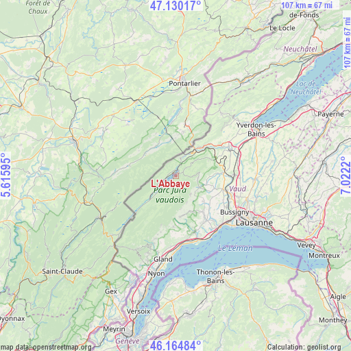
L'Abbaye GPS coordinates[2]
46° 38' 58.776" North, 6° 19' 8.652" East
| Map corner | latitude | longitude |
|---|---|---|
| Upper-left | 47.13017°, | 5.61595° |
| Center: | 46.64966°, | 6.31907° |
| Lower-right: | 46.16484°, | 7.0222° |
| Map W x H: | 107.3×107.3 km | = 66.7×66.7mi |
| max Lat: | 47.76737° ⇑80.6% North |
| L'Abbaye: | 46.64966° |
| min Lat: | ⇓19.4% South 45.83203° |
| min Long | L'Abbaye | max Long |
| 5.97153° | 6.31907° | 10.44624° |
| W 2.9%⇐ | ⇒97.1% E |
Elevation
Elevation of L'Abbaye is 1009 m = 3310 ft, and this is 450.8 m = 1479 ft above average elevation for this country.
| Max E: |
1845 m = 6053 ft | 4.9% |
| L'Abbaye | 1009 m 3310 ft | |
| Avg. | 558.2 m = 1831 ft | |
Min E: |
197 m = 646 ft | 95.1% |
See also: Switzerland elevation on elevation.city.
Geographical zone
L'Abbaye is located in North temperate zone (between Tropic of Cancer and the Arctic Circle). Distance of this North polar circle is 2214.2 km =1375.8 mi to North.| Distance of | km | miles | from L'Abbaye |
|---|---|---|---|
| North Pole | 4820.1 | 2995.1 | to North |
| Arctic Circle | 2214.2 | 1375.8 | to North |
| Tropic Cancer | 2581 | 1603.8 | to South |
| Equator | 5187 | 3223.1 | to South |


Nearby cities:
15 places around L'Abbaye: (largest is in red/bold)
• Ballaigues
11.5 km =7.1 mi,  38°
38°
• Ballens
11.3 km =7 mi,  158°
158°
• Berolle
10.3 km =6.4 mi,  172°
172°
• Bière
12.5 km =7.8 mi, 174°
• Chavannes-le-Veyron
11.1 km =6.9 mi,  115°
115°
• Chevilly
12.1 km =7.5 mi,  93°
93°
• Cuarnens
9.4 km =5.8 mi,  106°
106°
• La Chaux
12.2 km =7.6 mi, 107°
• Le Chenit
8.3 km =5.2 mi,  234°
234°
• Mauraz
9.2 km =5.7 mi, 122°
• Moiry
10.2 km =6.3 mi, 90°
• Mollens
8.7 km =5.4 mi, 157°
• Montricher
7.1 km =4.4 mi,  141°
141°
• Pampigny
11.4 km =7.1 mi,  132°
132°
• Vallorbe
8.4 km =5.2 mi,  33°
33°
Sources, notices
• [Note1] Compared only with cities in Switzerland existing in our database
• [Src1] Map data: © OpenStreetMap contributors (CC-BY-SA)
• [Src2] Other city data from geonames.org with taken over terms of usage.
• [Src3] Geographical zone / Annual Mean Temperature by Robert A. Rohde @ Wikipedia
