Laufenburg geodata
Laufenburg (Aargau) is a seat of a second-order administrative division; located in Switzerland in Europe/Zurich (GMT+2) time zone. With population of 2,000 people, there are 832 cities with bigger population in this country. Compared to other cities in Switzerland, 95.7% of cities are located further ↓South; 58.8% of cities are located further →East and 96.8% of cities have higher elevation than Laufenburg. Note1


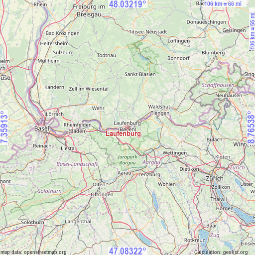
Laufenburg GPS coordinates[2]
47° 33' 35.46" North, 8° 3' 44.1" East
| Map corner | latitude | longitude |
|---|---|---|
| Upper-left | 48.03219°, | 7.35913° |
| Center: | 47.55985°, | 8.06225° |
| Lower-right: | 47.08322°, | 8.76538° |
| Map W x H: | 105.5×105.5 km | = 65.6×65.6mi |
| max Lat: | 47.76737° ⇑4.3% North |
| Laufenburg: | 47.55985° |
| min Lat: | ⇓95.7% South 45.83203° |
| min Long | Laufenburg | max Long |
| 5.97153° | 8.06225° | 10.44624° |
| W 41.2%⇐ | ⇒58.8% E |
Elevation
Elevation of Laufenburg is 318 m = 1043 ft, and this is 240.2 m = 788 ft below average elevation for this country.
| Max E: |
1845 m = 6053 ft | 96.8% |
| Avg. | 558.2 m = 1831 ft | |
| Laufenburg | 318 m = 1043 ft | |
Min E: |
197 m = 646 ft | 3.2% |
See also: Switzerland elevation on elevation.city.
Geographical zone
Laufenburg is located in North temperate zone (between Tropic of Cancer and the Arctic Circle). Distance of this North polar circle is 2113 km =1313 mi to North.| Distance of | km | miles | from Laufenburg |
|---|---|---|---|
| North Pole | 4718.9 | 2932.2 | to North |
| Arctic Circle | 2113 | 1313 | to North |
| Tropic Cancer | 2682.2 | 1666.6 | to South |
| Equator | 5288.2 | 3285.9 | to South |


Nearby cities:
15 places around Laufenburg: (largest is in red/bold)
• Bözen
7.3 km =4.5 mi,  166°
166°
• Effingen
8.5 km =5.3 mi,  158°
158°
• Eiken
6.3 km =3.9 mi,  242°
242°
• Frick
6.1 km =3.8 mi,  207°
207°
• Gansingen
5.8 km =3.6 mi,  109°
109°
• Gipf-Oberfrick
8 km =5 mi, 212°
• Hornussen
6.6 km =4.1 mi,  179°
179°
• Kaisten
2.5 km =1.6 mi, 214°
• Leibstadt
9.1 km =5.7 mi,  69°
69°
• Mumpf
10.7 km =6.6 mi,  261°
261°
• Schwaderloch
6.8 km =4.2 mi, 65°
• Stein
8.4 km =5.2 mi, 257°
• Sulz
3.7 km =2.3 mi,  136°
136°
• Wittnau
10.9 km =6.8 mi,  216°
216°
• Zeihen
9.4 km =5.8 mi, 169°
Sources, notices
• [Note1] Compared only with cities in Switzerland existing in our database
• [Src1] Map data: © OpenStreetMap contributors (CC-BY-SA)
• [Src2] Other city data from geonames.org with taken over terms of usage.
• [Src3] Geographical zone / Annual Mean Temperature by Robert A. Rohde @ Wikipedia
