Schwaderloch geodata
Schwaderloch (Aargau) is a seat of a third-order administrative division; located in Switzerland in Europe/Zurich (GMT+2) time zone. With population of 726 people, there are 1566 cities with bigger population in this country. Compared to other cities in Switzerland, 96.6% of cities are located further ↓South; 56.8% of cities are located further →East and 96.4% of cities have higher elevation than Schwaderloch. Note1


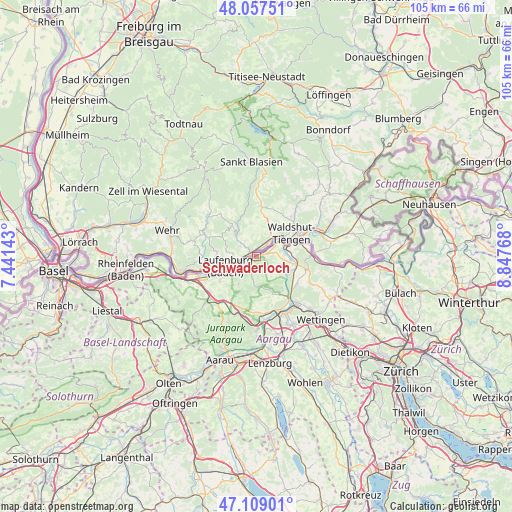
Schwaderloch GPS coordinates[2]
47° 35' 7.476" North, 8° 8' 40.38" East
| Map corner | latitude | longitude |
|---|---|---|
| Upper-left | 48.05751°, | 7.44143° |
| Center: | 47.58541°, | 8.14455° |
| Lower-right: | 47.10901°, | 8.84768° |
| Map W x H: | 105.5×105.5 km | = 65.6×65.6mi |
| max Lat: | 47.76737° ⇑3.4% North |
| Schwaderloch: | 47.58541° |
| min Lat: | ⇓96.6% South 45.83203° |
| min Long | Schwaderloch | max Long |
| 5.97153° | 8.14455° | 10.44624° |
| W 43.2%⇐ | ⇒56.8% E |
Elevation
Elevation of Schwaderloch is 329 m = 1079 ft, and this is 229.2 m = 752 ft below average elevation for this country.
| Max E: |
1845 m = 6053 ft | 96.4% |
| Avg. | 558.2 m = 1831 ft | |
| Schwaderloch | 329 m = 1079 ft | |
Min E: |
197 m = 646 ft | 3.6% |
See also: Switzerland elevation on elevation.city.
Geographical zone
Schwaderloch is located in North temperate zone (between Tropic of Cancer and the Arctic Circle). Distance of this North polar circle is 2110.2 km =1311.2 mi to North.| Distance of | km | miles | from Schwaderloch |
|---|---|---|---|
| North Pole | 4716.1 | 2930.4 | to North |
| Arctic Circle | 2110.2 | 1311.2 | to North |
| Tropic Cancer | 2685.1 | 1668.4 | to South |
| Equator | 5291 | 3287.7 | to South |


Nearby cities:
15 places around Schwaderloch: (largest is in red/bold)
• Bad Zurzach
11.2 km =7 mi,  88°
88°
• Bözen
10.9 km =6.8 mi,  204°
204°
• Effingen
11.2 km =7 mi, 196°
• Gansingen
4.8 km =3 mi,  188°
188°
• Hornussen
11.3 km =7 mi,  212°
212°
• Kaisten
9 km =5.6 mi,  237°
237°
• Klingnau
7.8 km =4.8 mi, 91°
• Koblenz
7.5 km =4.7 mi,  68°
68°
• Laufenburg
6.8 km =4.2 mi,  245°
245°
• Lauffohr (Brugg)
11.4 km =7.1 mi,  145°
145°
• Leibstadt
2.4 km =1.5 mi,  83°
83°
• Sulz
6.6 km =4.1 mi, 213°
• Tegerfelden
11.3 km =7 mi,  105°
105°
• Villigen
8.4 km =5.2 mi,  140°
140°
• Würenlingen
10.2 km =6.3 mi,  124°
124°
Sources, notices
• [Note1] Compared only with cities in Switzerland existing in our database
• [Src1] Map data: © OpenStreetMap contributors (CC-BY-SA)
• [Src2] Other city data from geonames.org with taken over terms of usage.
• [Src3] Geographical zone / Annual Mean Temperature by Robert A. Rohde @ Wikipedia
