Hornussen geodata
Hornussen (Aargau) is a populated place; located in Switzerland in Europe/Zurich (GMT+2) time zone. With population of 845 people, there are 1463 cities with bigger population in this country. Compared to other cities in Switzerland, 89.2% of cities are located further ↓South; 58.7% of cities are located further →East and 92.4% of cities have higher elevation than Hornussen. Note1


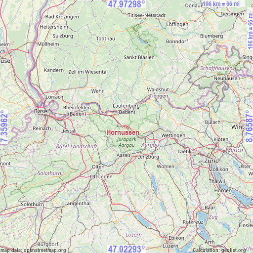
Hornussen GPS coordinates[2]
47° 30' 0.36" North, 8° 3' 45.9" East
| Map corner | latitude | longitude |
|---|---|---|
| Upper-left | 47.97298°, | 7.35962° |
| Center: | 47.5001°, | 8.06275° |
| Lower-right: | 47.02293°, | 8.76587° |
| Map W x H: | 105.6×105.6 km | = 65.6×65.6mi |
| max Lat: | 47.76737° ⇑10.8% North |
| Hornussen: | 47.5001° |
| min Lat: | ⇓89.2% South 45.83203° |
| min Long | Hornussen | max Long |
| 5.97153° | 8.06275° | 10.44624° |
| W 41.3%⇐ | ⇒58.7% E |
Elevation
Elevation of Hornussen is 384 m = 1260 ft, and this is 174.2 m = 572 ft below average elevation for this country.
| Max E: |
1845 m = 6053 ft | 92.4% |
| Avg. | 558.2 m = 1831 ft | |
| Hornussen | 384 m = 1260 ft | |
Min E: |
197 m = 646 ft | 7.6% |
See also: Switzerland elevation on elevation.city.
Geographical zone
Hornussen is located in North temperate zone (between Tropic of Cancer and the Arctic Circle). Distance of this North polar circle is 2119.7 km =1317.1 mi to North.| Distance of | km | miles | from Hornussen |
|---|---|---|---|
| North Pole | 4725.5 | 2936.3 | to North |
| Arctic Circle | 2119.7 | 1317.1 | to North |
| Tropic Cancer | 2675.6 | 1662.5 | to South |
| Equator | 5281.5 | 3281.8 | to South |


Nearby cities:
15 places around Hornussen: (largest is in red/bold)
• Bözen
1.7 km =1.1 mi,  106°
106°
• Densbüren
5.3 km =3.3 mi,  187°
187°
• Effingen
3.3 km =2.1 mi, 112°
• Eiken
6.7 km =4.2 mi,  303°
303°
• Frick
3.1 km =1.9 mi,  294°
294°
• Gansingen
7.2 km =4.5 mi,  48°
48°
• Gipf-Oberfrick
4.3 km =2.7 mi,  268°
268°
• Kaisten
4.8 km =3 mi,  342°
342°
• Laufenburg
6.6 km =4.1 mi,  359°
359°
• Oberhof
7.3 km =4.5 mi,  218°
218°
• Sulz
4.7 km =2.9 mi,  32°
32°
• Thalheim
7.7 km =4.8 mi,  158°
158°
• Wittnau
6.9 km =4.3 mi,  252°
252°
• Wölflinswil
6.5 km =4 mi,  227°
227°
• Zeihen
3.1 km =1.9 mi,  147°
147°
Sources, notices
• [Note1] Compared only with cities in Switzerland existing in our database
• [Src1] Map data: © OpenStreetMap contributors (CC-BY-SA)
• [Src2] Other city data from geonames.org with taken over terms of usage.
• [Src3] Geographical zone / Annual Mean Temperature by Robert A. Rohde @ Wikipedia
