Grandvillard geodata
Grandvillard (Fribourg) is a populated place; located in Switzerland in Europe/Zurich (GMT+2) time zone. With population of 616 people, there are 1680 cities with bigger population in this country. Compared to other cities in Switzerland, 84.2% of cities are located further ↑North; 85.2% of cities are located further →East and 86.9% of cities have lower elevation than Grandvillard. Note1


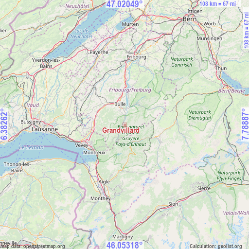
Grandvillard GPS coordinates[2]
46° 32' 20.364" North, 7° 5' 8.7" East
| Map corner | latitude | longitude |
|---|---|---|
| Upper-left | 47.02049°, | 6.38262° |
| Center: | 46.53899°, | 7.08575° |
| Lower-right: | 46.05318°, | 7.78887° |
| Map W x H: | 107.6×107.6 km | = 66.9×66.9mi |
| max Lat: | 47.76737° ⇑84.2% North |
| Grandvillard: | 46.53899° |
| min Lat: | ⇓15.8% South 45.83203° |
| min Long | Grandvillard | max Long |
| 5.97153° | 7.08575° | 10.44624° |
| W 14.8%⇐ | ⇒85.2% E |
Elevation
Elevation of Grandvillard is 763 m = 2503 ft, and this is 204.8 m = 672 ft above average elevation for this country.
| Max E: |
1845 m = 6053 ft | 13.1% |
| Grandvillard | 763 m 2503 ft | |
| Avg. | 558.2 m = 1831 ft | |
Min E: |
197 m = 646 ft | 86.9% |
See also: Switzerland elevation on elevation.city.
Geographical zone
Grandvillard is located in North temperate zone (between Tropic of Cancer and the Arctic Circle). Distance of this North polar circle is 2226.5 km =1383.5 mi to North.| Distance of | km | miles | from Grandvillard |
|---|---|---|---|
| North Pole | 4832.4 | 3002.7 | to North |
| Arctic Circle | 2226.5 | 1383.5 | to North |
| Tropic Cancer | 2568.7 | 1596.1 | to South |
| Equator | 5174.7 | 3215.4 | to South |


Nearby cities:
15 places around Grandvillard: (largest is in red/bold)
• Albeuve
3.3 km =2.1 mi,  222°
222°
• Broc
7.4 km =4.6 mi,  7°
7°
• Bulle
9.1 km =5.7 mi,  345°
345°
• Charmey
10.8 km =6.7 mi,  34°
34°
• Château-d'Oex
8 km =5 mi,  153°
153°
• Enney
3.1 km =1.9 mi,  357°
357°
• Gruyères
4.9 km =3 mi, 356°
• La Tour-de-Trême
8.1 km =5 mi, 348°
• Marsens
13.2 km =8.2 mi, 351°
• Riaz
11.6 km =7.2 mi, 350°
• Rossinière
7.9 km =4.9 mi,  181°
181°
• Rougemont
10.8 km =6.7 mi,  121°
121°
• Semsales
12.5 km =7.8 mi,  287°
287°
• Vaulruz
11.8 km =7.3 mi,  320°
320°
• Vuadens
10 km =6.2 mi,  328°
328°
Sources, notices
• [Note1] Compared only with cities in Switzerland existing in our database
• [Src1] Map data: © OpenStreetMap contributors (CC-BY-SA)
• [Src2] Other city data from geonames.org with taken over terms of usage.
• [Src3] Geographical zone / Annual Mean Temperature by Robert A. Rohde @ Wikipedia
