Kehrsatz geodata
Kehrsatz (Bern) is a populated place; located in Switzerland in Europe/Zurich (GMT+2) time zone. With population of 3,636 people, there are 490 cities with bigger population in this country. Compared to other cities in Switzerland, 68.9% of cities are located further ↑North; 76.4% of cities are located further →East and 69.8% of cities have lower elevation than Kehrsatz. Note1


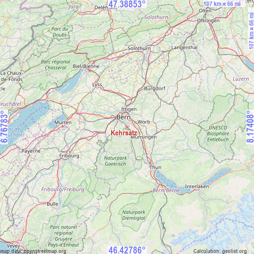
Kehrsatz GPS coordinates[2]
46° 54' 37.26" North, 7° 28' 15.456" East
| Map corner | latitude | longitude |
|---|---|---|
| Upper-left | 47.38853°, | 6.76783° |
| Center: | 46.91035°, | 7.47096° |
| Lower-right: | 46.42786°, | 8.17408° |
| Map W x H: | 106.8×106.8 km | = 66.4×66.4mi |
| max Lat: | 47.76737° ⇑68.9% North |
| Kehrsatz: | 46.91035° |
| min Lat: | ⇓31.1% South 45.83203° |
| min Long | Kehrsatz | max Long |
| 5.97153° | 7.47096° | 10.44624° |
| W 23.6%⇐ | ⇒76.4% E |
Elevation
Elevation of Kehrsatz is 572 m = 1877 ft, and this is 13.8 m = 45 ft above average elevation for this country.
| Max E: |
1845 m = 6053 ft | 30.2% |
| Kehrsatz | 572 m 1877 ft | |
| Avg. | 558.2 m = 1831 ft | |
Min E: |
197 m = 646 ft | 69.8% |
See also: Switzerland elevation on elevation.city.
Geographical zone
Kehrsatz is located in North temperate zone (between Tropic of Cancer and the Arctic Circle). Distance of this North polar circle is 2185.2 km =1357.8 mi to North.| Distance of | km | miles | from Kehrsatz |
|---|---|---|---|
| North Pole | 4791.1 | 2977.1 | to North |
| Arctic Circle | 2185.2 | 1357.8 | to North |
| Tropic Cancer | 2610 | 1621.8 | to South |
| Equator | 5215.9 | 3241 | to South |


Nearby cities:
15 places around Kehrsatz: (largest is in red/bold)
• Belp
3 km =1.9 mi,  135°
135°
• Bern
4.6 km =2.9 mi,  336°
336°
• Bolligen
7.5 km =4.7 mi,  15°
15°
• Köniz
4.6 km =2.9 mi,  289°
289°
• Muri
2.6 km =1.6 mi,  27°
27°
• Münsingen
8 km =5 mi,  121°
121°
• Niedermuhlern
5.8 km =3.6 mi,  183°
183°
• Oberbalm
6.6 km =4.1 mi,  231°
231°
• Ostermundigen
5.4 km =3.4 mi, 15°
• Rubigen
5.7 km =3.5 mi,  103°
103°
• Stettlen
6.7 km =4.2 mi,  37°
37°
• Toffen
5.8 km =3.6 mi,  163°
163°
• Vechigen
7.9 km =4.9 mi,  59°
59°
• Worb
7.3 km =4.5 mi,  72°
72°
• Zimmerwald
3.3 km =2.1 mi,  171°
171°
Sources, notices
• [Note1] Compared only with cities in Switzerland existing in our database
• [Src1] Map data: © OpenStreetMap contributors (CC-BY-SA)
• [Src2] Other city data from geonames.org with taken over terms of usage.
• [Src3] Geographical zone / Annual Mean Temperature by Robert A. Rohde @ Wikipedia
