Bolligen geodata
Bolligen (Bern) is a populated place; located in Switzerland in Europe/Zurich (GMT+2) time zone. With population of 6,086 people, there are 273 cities with bigger population in this country. Compared to other cities in Switzerland, 65.8% of cities are located further ↑North; 75.7% of cities are located further →East and 71.2% of cities have lower elevation than Bolligen. Note1


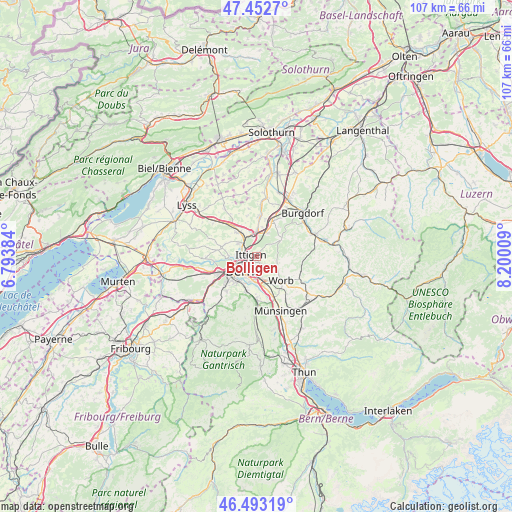
Bolligen GPS coordinates[2]
46° 58' 30.36" North, 7° 29' 49.092" East
| Map corner | latitude | longitude |
|---|---|---|
| Upper-left | 47.4527°, | 6.79384° |
| Center: | 46.9751°, | 7.49697° |
| Lower-right: | 46.49319°, | 8.20009° |
| Map W x H: | 106.7×106.7 km | = 66.3×66.3mi |
| max Lat: | 47.76737° ⇑65.8% North |
| Bolligen: | 46.9751° |
| min Lat: | ⇓34.2% South 45.83203° |
| min Long | Bolligen | max Long |
| 5.97153° | 7.49697° | 10.44624° |
| W 24.3%⇐ | ⇒75.7% E |
Elevation
Elevation of Bolligen is 582 m = 1909 ft, and this is 23.8 m = 78 ft above average elevation for this country.
| Max E: |
1845 m = 6053 ft | 28.8% |
| Bolligen | 582 m 1909 ft | |
| Avg. | 558.2 m = 1831 ft | |
Min E: |
197 m = 646 ft | 71.2% |
See also: Switzerland elevation on elevation.city.
Geographical zone
Bolligen is located in North temperate zone (between Tropic of Cancer and the Arctic Circle). Distance of this North polar circle is 2178 km =1353.3 mi to North.| Distance of | km | miles | from Bolligen |
|---|---|---|---|
| North Pole | 4783.9 | 2972.6 | to North |
| Arctic Circle | 2178 | 1353.3 | to North |
| Tropic Cancer | 2617.2 | 1626.3 | to South |
| Equator | 5223.1 | 3245.5 | to South |


Nearby cities:
15 places around Bolligen: (largest is in red/bold)
• Bern
4.8 km =3 mi,  231°
231°
• Bäriswil
5.4 km =3.4 mi,  24°
24°
• Hindelbank
8.2 km =5.1 mi, 24°
• Jegenstorf
8.1 km =5 mi,  5°
5°
• Kehrsatz
7.5 km =4.7 mi,  195°
195°
• Kirchlindach
6.6 km =4.1 mi,  294°
294°
• Krauchthal
6.5 km =4 mi,  53°
53°
• Muri
4.9 km =3 mi,  189°
189°
• Münchenbuchsee
6.3 km =3.9 mi,  325°
325°
• Ostermundigen
2.1 km =1.3 mi, 194°
• Stettlen
2.8 km =1.7 mi,  131°
131°
• Urtenen
5.7 km =3.5 mi,  2°
2°
• Vechigen
5.8 km =3.6 mi,  123°
123°
• Worb
7.1 km =4.4 mi,  135°
135°
• Zollikofen
4 km =2.5 mi,  312°
312°
Sources, notices
• [Note1] Compared only with cities in Switzerland existing in our database
• [Src1] Map data: © OpenStreetMap contributors (CC-BY-SA)
• [Src2] Other city data from geonames.org with taken over terms of usage.
• [Src3] Geographical zone / Annual Mean Temperature by Robert A. Rohde @ Wikipedia
