Ostermundigen geodata
Ostermundigen (Bern) is a seat of a third-order administrative division; located in Switzerland in Europe/Zurich (GMT+2) time zone. In our database, there are 1823 cities with bigger population. Compared to other cities in Switzerland, 66.5% of cities are located further ↑North; 75.9% of cities are located further →East and 66.1% of cities have lower elevation than Ostermundigen. Note1


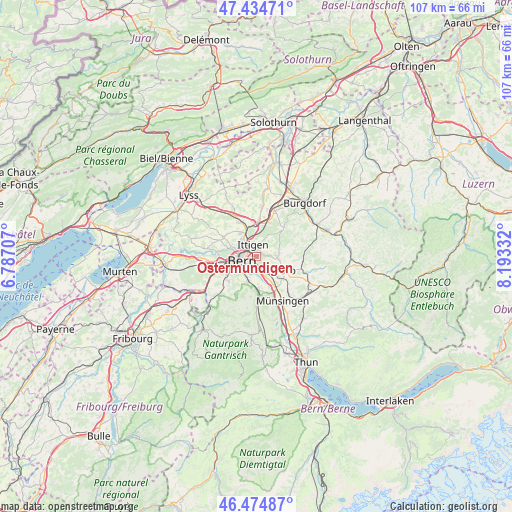
Ostermundigen GPS coordinates[2]
46° 57' 24.984" North, 7° 29' 24.684" East
| Map corner | latitude | longitude |
|---|---|---|
| Upper-left | 47.43471°, | 6.78707° |
| Center: | 46.95694°, | 7.49019° |
| Lower-right: | 46.47487°, | 8.19332° |
| Map W x H: | 106.7×106.7 km | = 66.3×66.3mi |
| max Lat: | 47.76737° ⇑66.5% North |
| Ostermundigen: | 46.95694° |
| min Lat: | ⇓33.5% South 45.83203° |
| min Long | Ostermundigen | max Long |
| 5.97153° | 7.49019° | 10.44624° |
| W 24.1%⇐ | ⇒75.9% E |
Elevation
Elevation of Ostermundigen is 550 m = 1804 ft, and this is 8.2 m = 27 ft below average elevation for this country.
| Max E: |
1845 m = 6053 ft | 33.9% |
| Avg. | 558.2 m = 1831 ft | |
| Ostermundigen | 550 m = 1804 ft | |
Min E: |
197 m = 646 ft | 66.1% |
See also: Switzerland elevation on elevation.city.
Geographical zone
Ostermundigen is located in North temperate zone (between Tropic of Cancer and the Arctic Circle). Distance of this North polar circle is 2180.1 km =1354.7 mi to North.| Distance of | km | miles | from Ostermundigen |
|---|---|---|---|
| North Pole | 4785.9 | 2973.8 | to North |
| Arctic Circle | 2180.1 | 1354.7 | to North |
| Tropic Cancer | 2615.2 | 1625 | to South |
| Equator | 5221.1 | 3244.2 | to South |


Nearby cities:
15 places around Ostermundigen: (largest is in red/bold)
• Belp
7.3 km =4.5 mi,  175°
175°
• Bern
3.4 km =2.1 mi,  253°
253°
• Bolligen
2.1 km =1.3 mi,  14°
14°
• Bäriswil
7.5 km =4.7 mi,  21°
21°
• Kehrsatz
5.4 km =3.4 mi,  195°
195°
• Kirchlindach
7.3 km =4.5 mi,  310°
310°
• Köniz
6.8 km =4.2 mi,  237°
237°
• Muri
2.9 km =1.8 mi,  185°
185°
• Münchenbuchsee
7.8 km =4.8 mi,  337°
337°
• Rubigen
7.7 km =4.8 mi,  147°
147°
• Stettlen
2.7 km =1.7 mi,  86°
86°
• Urtenen
7.8 km =4.8 mi, 5°
• Vechigen
5.5 km =3.4 mi,  102°
102°
• Worb
6.3 km =3.9 mi,  118°
118°
• Zollikofen
5.3 km =3.3 mi,  332°
332°
Sources, notices
• [Note1] Compared only with cities in Switzerland existing in our database
• [Src1] Map data: © OpenStreetMap contributors (CC-BY-SA)
• [Src2] Other city data from geonames.org with taken over terms of usage.
• [Src3] Geographical zone / Annual Mean Temperature by Robert A. Rohde @ Wikipedia
