Kallnach geodata
Kallnach (Bern) is a populated place; located in Switzerland in Europe/Zurich (GMT+2) time zone. With population of 1,545 people, there are 1011 cities with bigger population in this country. Compared to other cities in Switzerland, 63.4% of cities are located further ↑North; 81.2% of cities are located further →East and 56.3% of cities have higher elevation than Kallnach. Note1


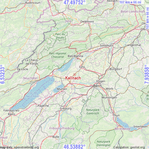
Kallnach GPS coordinates[2]
47° 1' 13.152" North, 7° 14' 7.62" East
| Map corner | latitude | longitude |
|---|---|---|
| Upper-left | 47.49752°, | 6.53233° |
| Center: | 47.02032°, | 7.23545° |
| Lower-right: | 46.53882°, | 7.93858° |
| Map W x H: | 106.6×106.6 km | = 66.2×66.2mi |
| max Lat: | 47.76737° ⇑63.4% North |
| Kallnach: | 47.02032° |
| min Lat: | ⇓36.6% South 45.83203° |
| min Long | Kallnach | max Long |
| 5.97153° | 7.23545° | 10.44624° |
| W 18.8%⇐ | ⇒81.2% E |
Elevation
Elevation of Kallnach is 464 m = 1522 ft, and this is 94.2 m = 309 ft below average elevation for this country.
| Max E: |
1845 m = 6053 ft | 56.3% |
| Avg. | 558.2 m = 1831 ft | |
| Kallnach | 464 m = 1522 ft | |
Min E: |
197 m = 646 ft | 43.7% |
See also: Switzerland elevation on elevation.city.
Geographical zone
Kallnach is located in North temperate zone (between Tropic of Cancer and the Arctic Circle). Distance of this North polar circle is 2173 km =1350.2 mi to North.| Distance of | km | miles | from Kallnach |
|---|---|---|---|
| North Pole | 4778.9 | 2969.5 | to North |
| Arctic Circle | 2173 | 1350.2 | to North |
| Tropic Cancer | 2622.3 | 1629.4 | to South |
| Equator | 5228.2 | 3248.7 | to South |


Nearby cities:
15 places around Kallnach: (largest is in red/bold)
• Aarberg
4.1 km =2.5 mi,  48°
48°
• Bellmund
9.8 km =6.1 mi,  4°
4°
• Brüttelen
6.6 km =4.1 mi,  272°
272°
• Ferenbalm
8.2 km =5.1 mi,  193°
193°
• Galmiz
9.9 km =6.2 mi,  216°
216°
• Kappelen
5.1 km =3.2 mi,  29°
29°
• Kerzers
5.8 km =3.6 mi,  211°
211°
• Lyss
8 km =5 mi,  42°
42°
• Mörigen
7.4 km =4.6 mi,  347°
347°
• Mühleberg
7.6 km =4.7 mi,  165°
165°
• Müntschemier
7.3 km =4.5 mi,  247°
247°
• Radelfingen
2.8 km =1.7 mi,  87°
87°
• Seedorf
6 km =3.7 mi,  74°
74°
• Siselen
3.8 km =2.4 mi,  290°
290°
• Täuffelen
5.8 km =3.6 mi,  331°
331°
Sources, notices
• [Note1] Compared only with cities in Switzerland existing in our database
• [Src1] Map data: © OpenStreetMap contributors (CC-BY-SA)
• [Src2] Other city data from geonames.org with taken over terms of usage.
• [Src3] Geographical zone / Annual Mean Temperature by Robert A. Rohde @ Wikipedia
