Ferenbalm geodata
Ferenbalm (Bern) is a populated place; located in Switzerland in Europe/Zurich (GMT+2) time zone. With population of 1,310 people, there are 1134 cities with bigger population in this country. Compared to other cities in Switzerland, 66.9% of cities are located further ↑North; 81.8% of cities are located further →East and 54.2% of cities have lower elevation than Ferenbalm. Note1


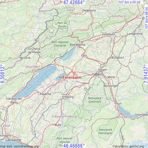
Ferenbalm GPS coordinates[2]
46° 56' 55.68" North, 7° 12' 40.464" East
| Map corner | latitude | longitude |
|---|---|---|
| Upper-left | 47.42664°, | 6.50812° |
| Center: | 46.9488°, | 7.21124° |
| Lower-right: | 46.46666°, | 7.91437° |
| Map W x H: | 106.7×106.7 km | = 66.3×66.3mi |
| max Lat: | 47.76737° ⇑66.9% North |
| Ferenbalm: | 46.9488° |
| min Lat: | ⇓33.1% South 45.83203° |
| min Long | Ferenbalm | max Long |
| 5.97153° | 7.21124° | 10.44624° |
| W 18.2%⇐ | ⇒81.8% E |
Elevation
Elevation of Ferenbalm is 492 m = 1614 ft, and this is 66.2 m = 217 ft below average elevation for this country.
| Max E: |
1845 m = 6053 ft | 45.8% |
| Avg. | 558.2 m = 1831 ft | |
| Ferenbalm | 492 m = 1614 ft | |
Min E: |
197 m = 646 ft | 54.2% |
See also: Switzerland elevation on elevation.city.
Geographical zone
Ferenbalm is located in North temperate zone (between Tropic of Cancer and the Arctic Circle). Distance of this North polar circle is 2181 km =1355.2 mi to North.| Distance of | km | miles | from Ferenbalm |
|---|---|---|---|
| North Pole | 4786.8 | 2974.4 | to North |
| Arctic Circle | 2181 | 1355.2 | to North |
| Tropic Cancer | 2614.3 | 1624.5 | to South |
| Equator | 5220.2 | 3243.7 | to South |


Nearby cities:
15 places around Ferenbalm: (largest is in red/bold)
• Bas-Vully
7.6 km =4.7 mi,  281°
281°
• Bösingen
6.4 km =4 mi,  168°
168°
• Courgevaux
8.9 km =5.5 mi,  237°
237°
• Galmiz
4 km =2.5 mi,  269°
269°
• Jeuss
6.2 km =3.9 mi,  216°
216°
• Kallnach
8.2 km =5.1 mi,  13°
13°
• Kerzers
3.2 km =2 mi,  338°
338°
• Kleinbösingen
6.1 km =3.8 mi,  184°
184°
• Laupen
5.6 km =3.5 mi,  157°
157°
• Liebistorf
4.6 km =2.9 mi,  194°
194°
• Murten/Morat
7.5 km =4.7 mi,  252°
252°
• Mühleberg
3.8 km =2.4 mi,  80°
80°
• Münchenwiler
7.6 km =4.7 mi, 238°
• Müntschemier
7.2 km =4.5 mi,  316°
316°
• Radelfingen
9.3 km =5.8 mi,  29°
29°
Sources, notices
• [Note1] Compared only with cities in Switzerland existing in our database
• [Src1] Map data: © OpenStreetMap contributors (CC-BY-SA)
• [Src2] Other city data from geonames.org with taken over terms of usage.
• [Src3] Geographical zone / Annual Mean Temperature by Robert A. Rohde @ Wikipedia
