Seedorf geodata
Seedorf (Bern) is a populated place; located in Switzerland in Europe/Zurich (GMT+2) time zone. With population of 2,920 people, there are 601 cities with bigger population in this country. Compared to other cities in Switzerland, 62.6% of cities are located further ↑North; 79.3% of cities are located further →East and 68.8% of cities have lower elevation than Seedorf. Note1


Seedorf GPS coordinates[2]
47° 2' 4.02" North, 7° 18' 44.964" East
| Map corner | latitude | longitude |
|---|---|---|
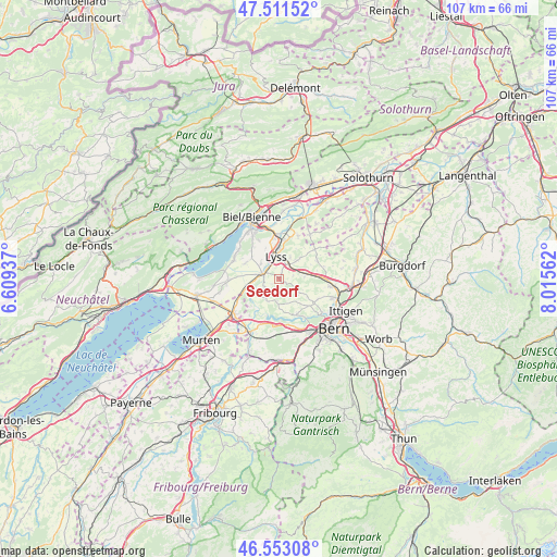
| Upper-left | 47.51152°, | 6.60937° |
| Center: | 47.03445°, | 7.31249° |
| Lower-right: | 46.55308°, | 8.01562° |
| Map W x H: | 106.6×106.6 km | = 66.2×66.2mi |
| max Lat: | 47.76737° ⇑62.6% North |
| Seedorf: | 47.03445° |
| min Lat: | ⇓37.4% South 45.83203° |
| min Long | Seedorf | max Long |
| 5.97153° | 7.31249° | 10.44624° |
| W 20.7%⇐ | ⇒79.3% E |
Elevation
Elevation of Seedorf is 566 m = 1857 ft, and this is 7.8 m = 26 ft above average elevation for this country.
| Max E: |
1845 m = 6053 ft | 31.2% |
| Seedorf | 566 m 1857 ft | |
| Avg. | 558.2 m = 1831 ft | |
Min E: |
197 m = 646 ft | 68.8% |
See also: Switzerland elevation on elevation.city.
Geographical zone
Seedorf is located in North temperate zone (between Tropic of Cancer and the Arctic Circle). Distance of this North polar circle is 2171.4 km =1349.2 mi to North.| Distance of | km | miles | from Seedorf |
|---|---|---|---|
| North Pole | 4777.3 | 2968.5 | to North |
| Arctic Circle | 2171.4 | 1349.2 | to North |
| Tropic Cancer | 2623.8 | 1630.4 | to South |
| Equator | 5229.7 | 3249.6 | to South |


Nearby cities:
15 places around Seedorf: (largest is in red/bold)
• Aarberg
3 km =1.9 mi,  291°
291°
• Frauenkappelen
9.1 km =5.7 mi,  167°
167°
• Grossaffoltern
4.8 km =3 mi,  44°
44°
• Kallnach
6 km =3.7 mi,  254°
254°
• Kappelen
4.4 km =2.7 mi,  310°
310°
• Kirchlindach
8.8 km =5.5 mi,  115°
115°
• Lyss
4.4 km =2.7 mi,  354°
354°
• Mörigen
9.3 km =5.8 mi, 307°
• Radelfingen
3.4 km =2.1 mi,  244°
244°
• Schüpfen
4.9 km =3 mi,  87°
87°
• Siselen
9.4 km =5.8 mi,  268°
268°
• Täuffelen
9.3 km =5.8 mi, 292°
• Wengi
8.6 km =5.3 mi,  50°
50°
• Wohlen
7.8 km =4.8 mi,  154°
154°
• Worben
7.7 km =4.8 mi, 350°
Sources, notices
• [Note1] Compared only with cities in Switzerland existing in our database
• [Src1] Map data: © OpenStreetMap contributors (CC-BY-SA)
• [Src2] Other city data from geonames.org with taken over terms of usage.
• [Src3] Geographical zone / Annual Mean Temperature by Robert A. Rohde @ Wikipedia
