Zürich (Kreis 10) / Höngg geodata
Zürich (Kreis 10) / Höngg (Zurich) is a section of populated place; located in Switzerland in Europe/Zurich (GMT+2) time zone. With population of 17,117 people, there are 55 cities with bigger population in this country. Compared to other cities in Switzerland, 74.4% of cities are located further ↓South; 56.5% of cities are located further ←West and 54.8% of cities have higher elevation than Zürich (Kreis 10) / Höngg. Note1
Current local time in Zürich (Kreis 10) / Höngg:
10:16 AM, SaturdayDifference from your time zone: hours


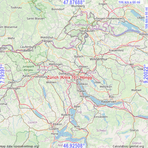
Zürich (Kreis 10) / Höngg GPS coordinates[2]
47° 24' 11.268" North, 8° 29' 49.56" East
| Map corner | latitude | longitude |
|---|---|---|
| Upper-left | 47.87688°, | 7.79397° |
| Center: | 47.40313°, | 8.4971° |
| Lower-right: | 46.92508°, | 9.20022° |
| Map W x H: | 105.8×105.8 km | = 65.7×65.7mi |
| max Lat: | 47.76737° ⇑25.6% North |
| Zürich (Kreis 10) / Höngg: | 47.40313° |
| min Lat: | ⇓74.4% South 45.83203° |
| min Long | Zürich (Kreis | max Long |
| 5.97153° | 8.4971° | 10.44624° |
| W 56.5%⇐ | ⇒43.5% E |
Elevation
Elevation of Zürich (Kreis 10) / Höngg is 468 m = 1535 ft, and this is 90.2 m = 296 ft below average elevation for this country.
| Max E: |
1845 m = 6053 ft | 54.8% |
| Avg. | 558.2 m = 1831 ft | |
| Zürich (Kreis 10) / Höngg | 468 m = 1535 ft | |
Min E: |
197 m = 646 ft | 45.2% |
See also: Switzerland elevation on elevation.city.
Geographical zone
Zürich (Kreis 10) / Höngg is located in North temperate zone (between Tropic of Cancer and the Arctic Circle). Distance of this North polar circle is 2130.4 km =1323.8 mi to North.| Distance of | km | miles | from Zürich (Kreis 10) / Höngg |
|---|---|---|---|
| North Pole | 4736.3 | 2943 | to North |
| Arctic Circle | 2130.4 | 1323.8 | to North |
| Tropic Cancer | 2664.8 | 1655.8 | to South |
| Equator | 5270.7 | 3275.1 | to South |


Nearby cities:
15 places around Zürich (Kreis 10) / Höngg: (largest is in red/bold)
• Oberengstringen
2.5 km =1.6 mi,  283°
283°
• Oberengstringen / Eggbühl
1.9 km =1.2 mi, 282°
• Oberengstringen / Kirchweg
1.9 km =1.2 mi, 276°
• Oberengstringen / Zentrum
2.6 km =1.6 mi, 279°
• Schlieren / Halde
2.8 km =1.7 mi,  253°
253°
• Schlieren / Industrie Ost
2.7 km =1.7 mi,  264°
264°
• Zürich (Kreis 10)
0.6 km =0.4 mi,  26°
26°
• Zürich (Kreis 10) / Rütihof
1.8 km =1.1 mi,  313°
313°
• Zürich (Kreis 10) / Wipkingen
2.3 km =1.4 mi,  113°
113°
• Zürich (Kreis 11) / Affoltern
2 km =1.2 mi, 34°
• Zürich (Kreis 4) / Hard
2.4 km =1.5 mi,  157°
157°
• Zürich (Kreis 5)
2.5 km =1.6 mi,  133°
133°
• Zürich (Kreis 5) / Escher-Wyss
1.8 km =1.1 mi,  139°
139°
• Zürich (Kreis 9)
2.6 km =1.6 mi,  209°
209°
• Zürich (Kreis 9) / Altstetten
1.8 km =1.1 mi, 210°
Sources, notices
• [Note1] Compared only with cities in Switzerland existing in our database
• [Src1] Map data: © OpenStreetMap contributors (CC-BY-SA)
• [Src2] Other city data from geonames.org with taken over terms of usage.
• [Src3] Geographical zone / Annual Mean Temperature by Robert A. Rohde @ Wikipedia
