Zürich (Kreis 11) / Affoltern geodata
Zürich (Kreis 11) / Affoltern (Zurich) is a section of populated place; located in Switzerland in Europe/Zurich (GMT+2) time zone. With population of 17,241 people, there are 54 cities with bigger population in this country. Compared to other cities in Switzerland, 77.3% of cities are located further ↓South; 57.4% of cities are located further ←West and 55.4% of cities have higher elevation than Zürich (Kreis 11) / Affoltern. Note1
Current local time in Zürich (Kreis 11) / Affoltern:
07:38 AM, SaturdayDifference from your time zone: hours


Zürich (Kreis 11) / Affoltern GPS coordinates[2]
47° 25' 5.304" North, 8° 30' 43.92" East
| Map corner | latitude | longitude |
|---|---|---|
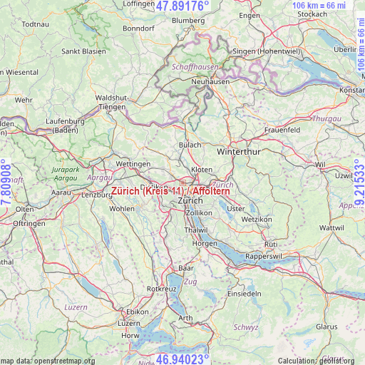
| Upper-left | 47.89176°, | 7.80908° |
| Center: | 47.41814°, | 8.5122° |
| Lower-right: | 46.94023°, | 9.21533° |
| Map W x H: | 105.8×105.8 km | = 65.7×65.7mi |
| max Lat: | 47.76737° ⇑22.7% North |
| Zürich (Kreis 11) / Affoltern: | 47.41814° |
| min Lat: | ⇓77.3% South 45.83203° |
| min Long | Zürich (Kreis | max Long |
| 5.97153° | 8.5122° | 10.44624° |
| W 57.4%⇐ | ⇒42.6% E |
Elevation
Elevation of Zürich (Kreis 11) / Affoltern is 466 m = 1529 ft, and this is 92.2 m = 302 ft below average elevation for this country.
| Max E: |
1845 m = 6053 ft | 55.4% |
| Avg. | 558.2 m = 1831 ft | |
| Zürich (Kreis 11) / Affoltern | 466 m = 1529 ft | |
Min E: |
197 m = 646 ft | 44.6% |
See also: Switzerland elevation on elevation.city.
Geographical zone
Zürich (Kreis 11) / Affoltern is located in North temperate zone (between Tropic of Cancer and the Arctic Circle). Distance of this North polar circle is 2128.8 km =1322.8 mi to North.| Distance of | km | miles | from Zürich (Kreis 11) / Affoltern |
|---|---|---|---|
| North Pole | 4734.7 | 2942 | to North |
| Arctic Circle | 2128.8 | 1322.8 | to North |
| Tropic Cancer | 2666.5 | 1656.9 | to South |
| Equator | 5272.4 | 3276.1 | to South |


Nearby cities:
15 places around Zürich (Kreis 11) / Affoltern: (largest is in red/bold)
• Oberengstringen / Eggbühl
3.2 km =2 mi,  247°
247°
• Oberengstringen / Kirchweg
3.3 km =2.1 mi,  244°
244°
• Regensdorf / Zentrum
3.5 km =2.2 mi,  293°
293°
• Rümlang / Huebacher
3.2 km =2 mi,  18°
18°
• Zürich (Kreis 10)
1.5 km =0.9 mi,  217°
217°
• Zürich (Kreis 10) / Höngg
2 km =1.2 mi,  214°
214°
• Zürich (Kreis 10) / Rütihof
2.5 km =1.6 mi,  260°
260°
• Zürich (Kreis 10) / Wipkingen
2.8 km =1.7 mi,  159°
159°
• Zürich (Kreis 11)
0.9 km =0.6 mi,  51°
51°
• Zürich (Kreis 11) / Oerlikon
2.5 km =1.6 mi,  115°
115°
• Zürich (Kreis 11) / Schwandenholz
1 km =0.6 mi,  42°
42°
• Zürich (Kreis 11) / Seebach
2.7 km =1.7 mi,  81°
81°
• Zürich (Kreis 5)
3.5 km =2.2 mi,  168°
168°
• Zürich (Kreis 5) / Escher-Wyss
3.1 km =1.9 mi,  178°
178°
• Zürich (Kreis 6) / Unterstrass
3.2 km =2 mi,  143°
143°
Sources, notices
• [Note1] Compared only with cities in Switzerland existing in our database
• [Src1] Map data: © OpenStreetMap contributors (CC-BY-SA)
• [Src2] Other city data from geonames.org with taken over terms of usage.
• [Src3] Geographical zone / Annual Mean Temperature by Robert A. Rohde @ Wikipedia
