Heimberg geodata
Heimberg (Bern) is a populated place; located in Switzerland in Europe/Zurich (GMT+2) time zone. With population of 5,501 people, there are 304 cities with bigger population in this country. Compared to other cities in Switzerland, 74.7% of cities are located further ↑North; 71.5% of cities are located further →East and 68.5% of cities have lower elevation than Heimberg. Note1


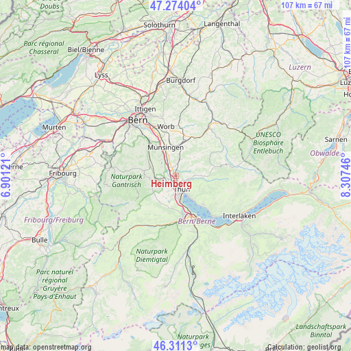
Heimberg GPS coordinates[2]
46° 47' 41.352" North, 7° 36' 15.588" East
| Map corner | latitude | longitude |
|---|---|---|
| Upper-left | 47.27404°, | 6.90121° |
| Center: | 46.79482°, | 7.60433° |
| Lower-right: | 46.3113°, | 8.30746° |
| Map W x H: | 107×107 km | = 66.5×66.5mi |
| max Lat: | 47.76737° ⇑74.7% North |
| Heimberg: | 46.79482° |
| min Lat: | ⇓25.3% South 45.83203° |
| min Long | Heimberg | max Long |
| 5.97153° | 7.60433° | 10.44624° |
| W 28.5%⇐ | ⇒71.5% E |
Elevation
Elevation of Heimberg is 564 m = 1850 ft, and this is 5.8 m = 19 ft above average elevation for this country.
| Max E: |
1845 m = 6053 ft | 31.5% |
| Heimberg | 564 m 1850 ft | |
| Avg. | 558.2 m = 1831 ft | |
Min E: |
197 m = 646 ft | 68.5% |
See also: Switzerland elevation on elevation.city.
Geographical zone
Heimberg is located in North temperate zone (between Tropic of Cancer and the Arctic Circle). Distance of this North polar circle is 2198.1 km =1365.8 mi to North.| Distance of | km | miles | from Heimberg |
|---|---|---|---|
| North Pole | 4804 | 2985.1 | to North |
| Arctic Circle | 2198.1 | 1365.8 | to North |
| Tropic Cancer | 2597.2 | 1613.8 | to South |
| Equator | 5203.1 | 3233.1 | to South |


Nearby cities:
15 places around Heimberg: (largest is in red/bold)
• Buchholterberg
5.7 km =3.5 mi,  68°
68°
• Fahrni
3.9 km =2.4 mi,  91°
91°
• Gerzensee
6.8 km =4.2 mi,  318°
318°
• Kiesen
3.2 km =2 mi,  330°
330°
• Kirchdorf
5.1 km =3.2 mi,  304°
304°
• Mühlethurnen
7.6 km =4.7 mi,  285°
285°
• Oberdiessbach
5.2 km =3.2 mi,  10°
10°
• Seftigen
5 km =3.1 mi,  260°
260°
• Steffisburg
2.8 km =1.7 mi,  130°
130°
• Thierachern
5.2 km =3.2 mi,  206°
206°
• Thun
5 km =3.1 mi,  164°
164°
• Uebeschi
7.3 km =4.5 mi, 210°
• Uetendorf
3.4 km =2.1 mi,  226°
226°
• Uttigen
2 km =1.2 mi,  268°
268°
• Wichtrach
6.5 km =4 mi,  341°
341°
Sources, notices
• [Note1] Compared only with cities in Switzerland existing in our database
• [Src1] Map data: © OpenStreetMap contributors (CC-BY-SA)
• [Src2] Other city data from geonames.org with taken over terms of usage.
• [Src3] Geographical zone / Annual Mean Temperature by Robert A. Rohde @ Wikipedia
