Steffisburg geodata
Steffisburg (Bern) is a populated place; located in Switzerland in Europe/Zurich (GMT+2) time zone. With population of 15,191 people, there are 80 cities with bigger population in this country. Compared to other cities in Switzerland, 75.6% of cities are located further ↑North; 70.4% of cities are located further →East and 71.5% of cities have lower elevation than Steffisburg. Note1


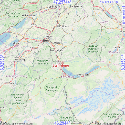
Steffisburg GPS coordinates[2]
46° 46' 41.052" North, 7° 37' 56.964" East
| Map corner | latitude | longitude |
|---|---|---|
| Upper-left | 47.25744°, | 6.92936° |
| Center: | 46.77807°, | 7.63249° |
| Lower-right: | 46.2944°, | 8.33561° |
| Map W x H: | 107.1×107.1 km | = 66.5×66.5mi |
| max Lat: | 47.76737° ⇑75.6% North |
| Steffisburg: | 46.77807° |
| min Lat: | ⇓24.4% South 45.83203° |
| min Long | Steffisburg | max Long |
| 5.97153° | 7.63249° | 10.44624° |
| W 29.6%⇐ | ⇒70.4% E |
Elevation
Elevation of Steffisburg is 584 m = 1916 ft, and this is 25.8 m = 85 ft above average elevation for this country.
| Max E: |
1845 m = 6053 ft | 28.5% |
| Steffisburg | 584 m 1916 ft | |
| Avg. | 558.2 m = 1831 ft | |
Min E: |
197 m = 646 ft | 71.5% |
See also: Switzerland elevation on elevation.city.
Geographical zone
Steffisburg is located in North temperate zone (between Tropic of Cancer and the Arctic Circle). Distance of this North polar circle is 2199.9 km =1367 mi to North.| Distance of | km | miles | from Steffisburg |
|---|---|---|---|
| North Pole | 4805.8 | 2986.2 | to North |
| Arctic Circle | 2199.9 | 1367 | to North |
| Tropic Cancer | 2595.3 | 1612.6 | to South |
| Equator | 5201.2 | 3231.9 | to South |


Nearby cities:
15 places around Steffisburg: (largest is in red/bold)
• Amsoldingen
6.8 km =4.2 mi,  214°
214°
• Buchholterberg
5.1 km =3.2 mi,  39°
39°
• Fahrni
2.5 km =1.6 mi, 44°
• Heiligenschwendi
4.9 km =3 mi,  127°
127°
• Heimberg
2.8 km =1.7 mi,  310°
310°
• Hilterfingen
5.3 km =3.3 mi,  154°
154°
• Kiesen
5.9 km =3.7 mi,  321°
321°
• Kirchdorf
8 km =5 mi, 306°
• Oberdiessbach
7.1 km =4.4 mi,  350°
350°
• Seftigen
7.2 km =4.5 mi,  278°
278°
• Thierachern
5.2 km =3.2 mi,  237°
237°
• Thun
3.1 km =1.9 mi,  195°
195°
• Uebeschi
7.4 km =4.6 mi,  232°
232°
• Uetendorf
4.6 km =2.9 mi,  264°
264°
• Uttigen
4.5 km =2.8 mi,  293°
293°
Sources, notices
• [Note1] Compared only with cities in Switzerland existing in our database
• [Src1] Map data: © OpenStreetMap contributors (CC-BY-SA)
• [Src2] Other city data from geonames.org with taken over terms of usage.
• [Src3] Geographical zone / Annual Mean Temperature by Robert A. Rohde @ Wikipedia
