Uttigen geodata
Uttigen (Bern) is a populated place; located in Switzerland in Europe/Zurich (GMT+2) time zone. With population of 1,673 people, there are 953 cities with bigger population in this country. Compared to other cities in Switzerland, 74.8% of cities are located further ↑North; 72.4% of cities are located further →East and 64.4% of cities have lower elevation than Uttigen. Note1


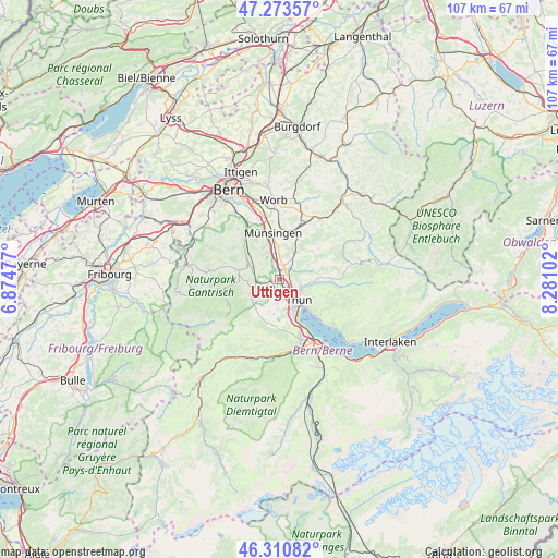
Uttigen GPS coordinates[2]
46° 47' 39.66" North, 7° 34' 40.404" East
| Map corner | latitude | longitude |
|---|---|---|
| Upper-left | 47.27357°, | 6.87477° |
| Center: | 46.79435°, | 7.57789° |
| Lower-right: | 46.31082°, | 8.28102° |
| Map W x H: | 107×107 km | = 66.5×66.5mi |
| max Lat: | 47.76737° ⇑74.8% North |
| Uttigen: | 46.79435° |
| min Lat: | ⇓25.2% South 45.83203° |
| min Long | Uttigen | max Long |
| 5.97153° | 7.57789° | 10.44624° |
| W 27.6%⇐ | ⇒72.4% E |
Elevation
Elevation of Uttigen is 543 m = 1781 ft, and this is 15.2 m = 50 ft below average elevation for this country.
| Max E: |
1845 m = 6053 ft | 35.6% |
| Avg. | 558.2 m = 1831 ft | |
| Uttigen | 543 m = 1781 ft | |
Min E: |
197 m = 646 ft | 64.4% |
See also: Switzerland elevation on elevation.city.
Geographical zone
Uttigen is located in North temperate zone (between Tropic of Cancer and the Arctic Circle). Distance of this North polar circle is 2198.1 km =1365.8 mi to North.| Distance of | km | miles | from Uttigen |
|---|---|---|---|
| North Pole | 4804 | 2985.1 | to North |
| Arctic Circle | 2198.1 | 1365.8 | to North |
| Tropic Cancer | 2597.1 | 1613.8 | to South |
| Equator | 5203 | 3233 | to South |


Nearby cities:
15 places around Uttigen: (largest is in red/bold)
• Burgistein
6 km =3.7 mi,  259°
259°
• Fahrni
5.9 km =3.7 mi,  90°
90°
• Gerzensee
5.7 km =3.5 mi,  333°
333°
• Heimberg
2 km =1.2 mi, 88°
• Kiesen
2.8 km =1.7 mi,  9°
9°
• Kirchdorf
3.7 km =2.3 mi,  322°
322°
• Mühlethurnen
5.7 km =3.5 mi,  291°
291°
• Oberdiessbach
6 km =3.7 mi,  29°
29°
• Seftigen
3 km =1.9 mi, 255°
• Steffisburg
4.5 km =2.8 mi,  113°
113°
• Thierachern
4.6 km =2.9 mi,  183°
183°
• Thun
5.8 km =3.6 mi,  145°
145°
• Uetendorf
2.3 km =1.4 mi,  190°
190°
• Wattenwil
6 km =3.7 mi,  242°
242°
• Wichtrach
6.2 km =3.9 mi,  359°
359°
Sources, notices
• [Note1] Compared only with cities in Switzerland existing in our database
• [Src1] Map data: © OpenStreetMap contributors (CC-BY-SA)
• [Src2] Other city data from geonames.org with taken over terms of usage.
• [Src3] Geographical zone / Annual Mean Temperature by Robert A. Rohde @ Wikipedia
