Rougemont geodata
Rougemont (Vaud) is a populated place; located in Switzerland in Europe/Zurich (GMT+2) time zone. With population of 909 people, there are 1408 cities with bigger population in this country. Compared to other cities in Switzerland, 86.1% of cities are located further ↑North; 82% of cities are located further →East and 94.5% of cities have lower elevation than Rougemont. Note1
Administrative division(s):
- Level 1: Vaud
- Level 2: Riviera-Pays-d'Enhaut District
- Level 3: Rougemont


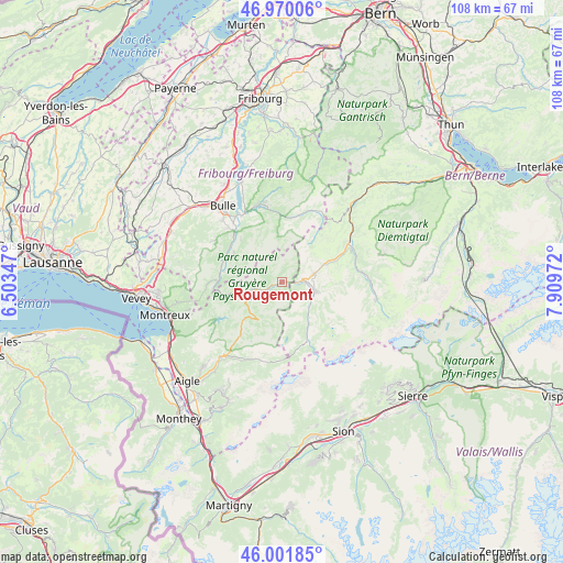
Rougemont GPS coordinates[2]
46° 29' 17.196" North, 7° 12' 23.724" East
| Map corner | latitude | longitude |
|---|---|---|
| Upper-left | 46.97006°, | 6.50347° |
| Center: | 46.48811°, | 7.20659° |
| Lower-right: | 46.00185°, | 7.90972° |
| Map W x H: | 107.7×107.7 km | = 66.9×66.9mi |
| max Lat: | 47.76737° ⇑86.1% North |
| Rougemont: | 46.48811° |
| min Lat: | ⇓13.9% South 45.83203° |
| min Long | Rougemont | max Long |
| 5.97153° | 7.20659° | 10.44624° |
| W 18%⇐ | ⇒82% E |
Elevation
Elevation of Rougemont is 990 m = 3248 ft, and this is 431.8 m = 1417 ft above average elevation for this country.
| Max E: |
1845 m = 6053 ft | 5.5% |
| Rougemont | 990 m 3248 ft | |
| Avg. | 558.2 m = 1831 ft | |
Min E: |
197 m = 646 ft | 94.5% |
See also: Switzerland elevation on elevation.city.
Geographical zone
Rougemont is located in North temperate zone (between Tropic of Cancer and the Arctic Circle). Distance of this North polar circle is 2232.2 km =1387 mi to North.| Distance of | km | miles | from Rougemont |
|---|---|---|---|
| North Pole | 4838.1 | 3006.3 | to North |
| Arctic Circle | 2232.2 | 1387 | to North |
| Tropic Cancer | 2563.1 | 1592.6 | to South |
| Equator | 5169 | 3211.9 | to South |


Nearby cities:
15 places around Rougemont: (largest is in red/bold)
• Albeuve
11.9 km =7.4 mi,  285°
285°
• Broc
15.4 km =9.6 mi,  327°
327°
• Charmey
15 km =9.3 mi,  347°
347°
• Château-d'Oex
5.9 km =3.7 mi,  255°
255°
• Enney
12.8 km =8 mi,  313°
313°
• Grandvillard
10.8 km =6.7 mi,  301°
301°
• Gruyères
14.2 km =8.8 mi,  318°
318°
• Gstaad
6.4 km =4 mi,  106°
106°
• Jaun
14.7 km =9.1 mi,  21°
21°
• La Tour-de-Trême
17.4 km =10.8 mi, 321°
• Lenk
18.4 km =11.4 mi,  100°
100°
• Rossinière
9.7 km =6 mi, 256°
• Saanen
4.1 km =2.5 mi,  87°
87°
• Sankt Stephan
14.6 km =9.1 mi,  81°
81°
• Zweisimmen
14.8 km =9.2 mi,  59°
59°
Sources, notices
• [Note1] Compared only with cities in Switzerland existing in our database
• [Src1] Map data: © OpenStreetMap contributors (CC-BY-SA)
• [Src2] Other city data from geonames.org with taken over terms of usage.
• [Src3] Geographical zone / Annual Mean Temperature by Robert A. Rohde @ Wikipedia
