Gebenstorf geodata
Gebenstorf (Aargau) is a populated place; located in Switzerland in Europe/Zurich (GMT+2) time zone. With population of 4,100 people, there are 426 cities with bigger population in this country. Compared to other cities in Switzerland, 86.5% of cities are located further ↓South; 54.6% of cities are located further →East and 95.7% of cities have higher elevation than Gebenstorf. Note1


Gebenstorf GPS coordinates[2]
47° 28' 52.896" North, 8° 14' 22.164" East
| Map corner | latitude | longitude |
|---|---|---|
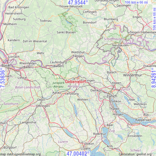
| Upper-left | 47.9544°, | 7.53636° |
| Center: | 47.48136°, | 8.23949° |
| Lower-right: | 47.00402°, | 8.94261° |
| Map W x H: | 105.7×105.7 km | = 65.7×65.7mi |
| max Lat: | 47.76737° ⇑13.5% North |
| Gebenstorf: | 47.48136° |
| min Lat: | ⇓86.5% South 45.83203° |
| min Long | Gebenstorf | max Long |
| 5.97153° | 8.23949° | 10.44624° |
| W 45.4%⇐ | ⇒54.6% E |
Elevation
Elevation of Gebenstorf is 341 m = 1119 ft, and this is 217.2 m = 713 ft below average elevation for this country.
| Max E: |
1845 m = 6053 ft | 95.7% |
| Avg. | 558.2 m = 1831 ft | |
| Gebenstorf | 341 m = 1119 ft | |
Min E: |
197 m = 646 ft | 4.3% |
See also: Switzerland elevation on elevation.city.
Geographical zone
Gebenstorf is located in North temperate zone (between Tropic of Cancer and the Arctic Circle). Distance of this North polar circle is 2121.7 km =1318.4 mi to North.| Distance of | km | miles | from Gebenstorf |
|---|---|---|---|
| North Pole | 4727.6 | 2937.6 | to North |
| Arctic Circle | 2121.7 | 1318.4 | to North |
| Tropic Cancer | 2673.5 | 1661.2 | to South |
| Equator | 5279.4 | 3280.5 | to South |


Nearby cities:
15 places around Gebenstorf: (largest is in red/bold)
• Baden
5.1 km =3.2 mi,  100°
100°
• Birmenstorf
2.3 km =1.4 mi,  163°
163°
• Birr
5.7 km =3.5 mi,  203°
203°
• Brugg
2.3 km =1.4 mi,  268°
268°
• Hausen
2.9 km =1.8 mi,  228°
228°
• Lauffohr (Brugg)
2.3 km =1.4 mi,  344°
344°
• Obersiggenthal
4.3 km =2.7 mi,  80°
80°
• Schinznach Bad
6.4 km =4 mi,  236°
236°
• Turgi
1.6 km =1 mi,  42°
42°
• Untersiggenthal
2.6 km =1.6 mi,  27°
27°
• Villigen
5.4 km =3.4 mi, 339°
• Villnachern
6.1 km =3.8 mi,  259°
259°
• Wettingen
5.9 km =3.7 mi, 101°
• Windisch
1.6 km =1 mi, 260°
• Würenlingen
5.9 km =3.7 mi,  12°
12°
Sources, notices
• [Note1] Compared only with cities in Switzerland existing in our database
• [Src1] Map data: © OpenStreetMap contributors (CC-BY-SA)
• [Src2] Other city data from geonames.org with taken over terms of usage.
• [Src3] Geographical zone / Annual Mean Temperature by Robert A. Rohde @ Wikipedia
