Untersiggenthal geodata
Untersiggenthal (Aargau) is a populated place; located in Switzerland in Europe/Zurich (GMT+2) time zone. With population of 6,344 people, there are 265 cities with bigger population in this country. Compared to other cities in Switzerland, 89.5% of cities are located further ↓South; 54% of cities are located further →East and 92.2% of cities have higher elevation than Untersiggenthal. Note1


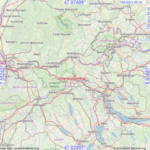
Untersiggenthal GPS coordinates[2]
47° 30' 7.668" North, 8° 15' 19.944" East
| Map corner | latitude | longitude |
|---|---|---|
| Upper-left | 47.97499°, | 7.55242° |
| Center: | 47.50213°, | 8.25554° |
| Lower-right: | 47.02497°, | 8.95867° |
| Map W x H: | 105.6×105.6 km | = 65.6×65.6mi |
| max Lat: | 47.76737° ⇑10.5% North |
| Untersiggenthal: | 47.50213° |
| min Lat: | ⇓89.5% South 45.83203° |
| min Long | Untersiggenthal | max Long |
| 5.97153° | 8.25554° | 10.44624° |
| W 46%⇐ | ⇒54% E |
Elevation
Elevation of Untersiggenthal is 385 m = 1263 ft, and this is 173.2 m = 568 ft below average elevation for this country.
| Max E: |
1845 m = 6053 ft | 92.2% |
| Avg. | 558.2 m = 1831 ft | |
| Untersiggenthal | 385 m = 1263 ft | |
Min E: |
197 m = 646 ft | 7.8% |
See also: Switzerland elevation on elevation.city.
Geographical zone
Untersiggenthal is located in North temperate zone (between Tropic of Cancer and the Arctic Circle). Distance of this North polar circle is 2119.4 km =1316.9 mi to North.| Distance of | km | miles | from Untersiggenthal |
|---|---|---|---|
| North Pole | 4725.3 | 2936.2 | to North |
| Arctic Circle | 2119.4 | 1316.9 | to North |
| Tropic Cancer | 2675.8 | 1662.7 | to South |
| Equator | 5281.7 | 3281.9 | to South |


Nearby cities:
15 places around Untersiggenthal: (largest is in red/bold)
• Baden
5 km =3.1 mi,  130°
130°
• Birmenstorf
4.5 km =2.8 mi,  187°
187°
• Brugg
4.2 km =2.6 mi,  236°
236°
• Ehrendingen
6.9 km =4.3 mi,  89°
89°
• Endingen
4.7 km =2.9 mi,  33°
33°
• Gebenstorf
2.6 km =1.6 mi,  207°
207°
• Hausen
5.5 km =3.4 mi,  218°
218°
• Lauffohr (Brugg)
1.8 km =1.1 mi,  267°
267°
• Obersiggenthal
3.5 km =2.2 mi,  117°
117°
• Tegerfelden
6.7 km =4.2 mi,  22°
22°
• Turgi
1.1 km =0.7 mi, 185°
• Villigen
4.1 km =2.5 mi,  311°
311°
• Wettingen
5.8 km =3.6 mi, 127°
• Windisch
3.8 km =2.4 mi,  227°
227°
• Würenlingen
3.5 km =2.2 mi,  1°
1°
Sources, notices
• [Note1] Compared only with cities in Switzerland existing in our database
• [Src1] Map data: © OpenStreetMap contributors (CC-BY-SA)
• [Src2] Other city data from geonames.org with taken over terms of usage.
• [Src3] Geographical zone / Annual Mean Temperature by Robert A. Rohde @ Wikipedia
