Amden geodata
Amden (Saint Gallen) is a seat of a third-order administrative division; located in Switzerland in Europe/Zurich (GMT+2) time zone. With population of 1,557 people, there are 1003 cities with bigger population in this country. Compared to other cities in Switzerland, 56.3% of cities are located further ↑North; 91.9% of cities are located further ←West and 92.6% of cities have lower elevation than Amden. Note1


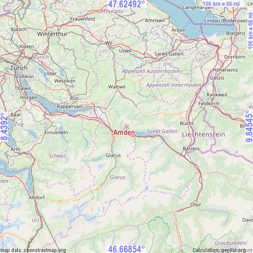
Amden GPS coordinates[2]
47° 8' 55.968" North, 9° 8' 32.388" East
| Map corner | latitude | longitude |
|---|---|---|
| Upper-left | 47.62492°, | 8.4392° |
| Center: | 47.14888°, | 9.14233° |
| Lower-right: | 46.66854°, | 9.84545° |
| Map W x H: | 106.3×106.3 km | = 66.1×66.1mi |
| max Lat: | 47.76737° ⇑56.3% North |
| Amden: | 47.14888° |
| min Lat: | ⇓43.7% South 45.83203° |
| min Long | Amden | max Long |
| 5.97153° | 9.14233° | 10.44624° |
| W 91.9%⇐ | ⇒8.1% E |
Elevation
Elevation of Amden is 910 m = 2986 ft, and this is 351.8 m = 1154 ft above average elevation for this country.
| Max E: |
1845 m = 6053 ft | 7.4% |
| Amden | 910 m 2986 ft | |
| Avg. | 558.2 m = 1831 ft | |
Min E: |
197 m = 646 ft | 92.6% |
See also: Switzerland elevation on elevation.city.
Geographical zone
Amden is located in North temperate zone (between Tropic of Cancer and the Arctic Circle). Distance of this North polar circle is 2158.7 km =1341.4 mi to North.| Distance of | km | miles | from Amden |
|---|---|---|---|
| North Pole | 4764.6 | 2960.6 | to North |
| Arctic Circle | 2158.7 | 1341.4 | to North |
| Tropic Cancer | 2636.5 | 1638.2 | to South |
| Equator | 5242.5 | 3257.5 | to South |


Nearby cities:
15 places around Amden: (largest is in red/bold)
• Benken
11.6 km =7.2 mi,  298°
298°
• Bilten
8.8 km =5.5 mi,  270°
270°
• Ebnat-Kappel
12.6 km =7.8 mi,  353°
353°
• Filzbach
3.4 km =2.1 mi,  192°
192°
• Kaltbrunn
11.4 km =7.1 mi,  309°
309°
• Krummenau
11.2 km =7 mi,  11°
11°
• Mollis
8.5 km =5.3 mi,  218°
218°
• Netstal
11.5 km =7.1 mi,  214°
214°
• Niederurnen
7.1 km =4.4 mi,  249°
249°
• Näfels
8.2 km =5.1 mi,  226°
226°
• Oberurnen
7.4 km =4.6 mi,  238°
238°
• Quarten
8.9 km =5.5 mi,  121°
121°
• Reichenburg
12.7 km =7.9 mi,  281°
281°
• Schänis
7.4 km =4.6 mi, 279°
• Weesen
3.8 km =2.4 mi, 245°
Sources, notices
• [Note1] Compared only with cities in Switzerland existing in our database
• [Src1] Map data: © OpenStreetMap contributors (CC-BY-SA)
• [Src2] Other city data from geonames.org with taken over terms of usage.
• [Src3] Geographical zone / Annual Mean Temperature by Robert A. Rohde @ Wikipedia
