Weesen geodata
Weesen (Saint Gallen) is a populated place; located in Switzerland in Europe/Zurich (GMT+2) time zone. With population of 1,402 people, there are 1084 cities with bigger population in this country. Compared to other cities in Switzerland, 57.2% of cities are located further ↑North; 90.9% of cities are located further ←West and 78.9% of cities have higher elevation than Weesen. Note1


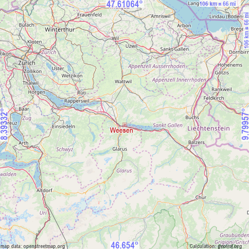
Weesen GPS coordinates[2]
47° 8' 4.092" North, 9° 5' 47.184" East
| Map corner | latitude | longitude |
|---|---|---|
| Upper-left | 47.61064°, | 8.39332° |
| Center: | 47.13447°, | 9.09644° |
| Lower-right: | 46.654°, | 9.79957° |
| Map W x H: | 106.4×106.4 km | = 66.1×66.1mi |
| max Lat: | 47.76737° ⇑57.2% North |
| Weesen: | 47.13447° |
| min Lat: | ⇓42.8% South 45.83203° |
| min Long | Weesen | max Long |
| 5.97153° | 9.09644° | 10.44624° |
| W 90.9%⇐ | ⇒9.1% E |
Elevation
Elevation of Weesen is 424 m = 1391 ft, and this is 134.2 m = 440 ft below average elevation for this country.
| Max E: |
1845 m = 6053 ft | 78.9% |
| Avg. | 558.2 m = 1831 ft | |
| Weesen | 424 m = 1391 ft | |
Min E: |
197 m = 646 ft | 21.1% |
See also: Switzerland elevation on elevation.city.
Geographical zone
Weesen is located in North temperate zone (between Tropic of Cancer and the Arctic Circle). Distance of this North polar circle is 2160.3 km =1342.3 mi to North.| Distance of | km | miles | from Weesen |
|---|---|---|---|
| North Pole | 4766.2 | 2961.6 | to North |
| Arctic Circle | 2160.3 | 1342.3 | to North |
| Tropic Cancer | 2634.9 | 1637.3 | to South |
| Equator | 5240.9 | 3256.5 | to South |


Nearby cities:
15 places around Weesen: (largest is in red/bold)
• Amden
3.8 km =2.4 mi,  65°
65°
• Benken
9.9 km =6.2 mi,  316°
316°
• Bilten
5.6 km =3.5 mi,  287°
287°
• Ennenda
11.3 km =7 mi,  186°
186°
• Filzbach
3.2 km =2 mi,  122°
122°
• Glarus
10.7 km =6.6 mi, 191°
• Kaltbrunn
10.3 km =6.4 mi,  328°
328°
• Mollis
5.4 km =3.4 mi,  199°
199°
• Netstal
8.4 km =5.2 mi, 200°
• Niederurnen
3.3 km =2.1 mi,  253°
253°
• Näfels
4.8 km =3 mi,  211°
211°
• Oberurnen
3.6 km =2.2 mi,  231°
231°
• Quarten
11.4 km =7.1 mi,  105°
105°
• Reichenburg
9.9 km =6.2 mi, 294°
• Schänis
4.8 km =3 mi,  306°
306°
Sources, notices
• [Note1] Compared only with cities in Switzerland existing in our database
• [Src1] Map data: © OpenStreetMap contributors (CC-BY-SA)
• [Src2] Other city data from geonames.org with taken over terms of usage.
• [Src3] Geographical zone / Annual Mean Temperature by Robert A. Rohde @ Wikipedia
