Schafisheim geodata
Schafisheim (Aargau) is a populated place; located in Switzerland in Europe/Zurich (GMT+2) time zone. With population of 2,758 people, there are 642 cities with bigger population in this country. Compared to other cities in Switzerland, 68.7% of cities are located further ↓South; 56.9% of cities are located further →East and 83.4% of cities have higher elevation than Schafisheim. Note1


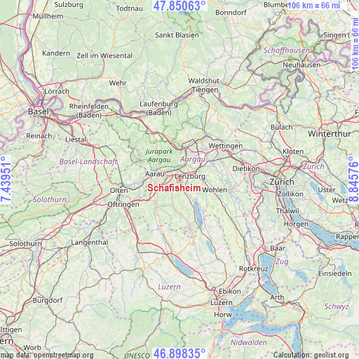
Schafisheim GPS coordinates[2]
47° 22' 35.904" North, 8° 8' 33.468" East
| Map corner | latitude | longitude |
|---|---|---|
| Upper-left | 47.85063°, | 7.43951° |
| Center: | 47.37664°, | 8.14263° |
| Lower-right: | 46.89835°, | 8.84576° |
| Map W x H: | 105.9×105.9 km | = 65.8×65.8mi |
| max Lat: | 47.76737° ⇑31.3% North |
| Schafisheim: | 47.37664° |
| min Lat: | ⇓68.7% South 45.83203° |
| min Long | Schafisheim | max Long |
| 5.97153° | 8.14263° | 10.44624° |
| W 43.1%⇐ | ⇒56.9% E |
Elevation
Elevation of Schafisheim is 414 m = 1358 ft, and this is 144.2 m = 473 ft below average elevation for this country.
| Max E: |
1845 m = 6053 ft | 83.4% |
| Avg. | 558.2 m = 1831 ft | |
| Schafisheim | 414 m = 1358 ft | |
Min E: |
197 m = 646 ft | 16.6% |
See also: Switzerland elevation on elevation.city.
Geographical zone
Schafisheim is located in North temperate zone (between Tropic of Cancer and the Arctic Circle). Distance of this North polar circle is 2133.4 km =1325.6 mi to North.| Distance of | km | miles | from Schafisheim |
|---|---|---|---|
| North Pole | 4739.3 | 2944.9 | to North |
| Arctic Circle | 2133.4 | 1325.6 | to North |
| Tropic Cancer | 2661.9 | 1654 | to South |
| Equator | 5267.8 | 3273.3 | to South |


Nearby cities:
15 places around Schafisheim: (largest is in red/bold)
• Biberstein
6.2 km =3.9 mi,  315°
315°
• Buchs
4.9 km =3 mi,  292°
292°
• Dürrenäsch
6.3 km =3.9 mi,  168°
168°
• Egliswil
4.4 km =2.7 mi,  133°
133°
• Gränichen
3.6 km =2.2 mi,  237°
237°
• Hendschiken
5.8 km =3.6 mi,  79°
79°
• Lenzburg
2.8 km =1.7 mi,  61°
61°
• Niederlenz
3.7 km =2.3 mi,  43°
43°
• Othmarsingen
6 km =3.7 mi, 62°
• Rupperswil
2.9 km =1.8 mi,  339°
339°
• Seon
3.4 km =2.1 mi,  156°
156°
• Staufen
1.9 km =1.2 mi,  71°
71°
• Suhr
4.8 km =3 mi,  263°
263°
• Teufenthal
5.6 km =3.5 mi,  199°
199°
• Veltheim
6.8 km =4.2 mi,  2°
2°
Sources, notices
• [Note1] Compared only with cities in Switzerland existing in our database
• [Src1] Map data: © OpenStreetMap contributors (CC-BY-SA)
• [Src2] Other city data from geonames.org with taken over terms of usage.
• [Src3] Geographical zone / Annual Mean Temperature by Robert A. Rohde @ Wikipedia
