Dompierre geodata
Dompierre (Fribourg) is a populated place; located in Switzerland in Europe/Zurich (GMT+2) time zone. With population of 687 people, there are 1613 cities with bigger population in this country. Compared to other cities in Switzerland, 71.8% of cities are located further ↑North; 88% of cities are located further →East and 58.2% of cities have higher elevation than Dompierre. Note1


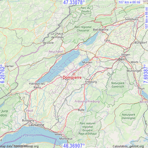
Dompierre GPS coordinates[2]
46° 51' 7.488" North, 6° 59' 26.7" East
| Map corner | latitude | longitude |
|---|---|---|
| Upper-left | 47.33078°, | 6.28762° |
| Center: | 46.85208°, | 6.99075° |
| Lower-right: | 46.36907°, | 7.69387° |
| Map W x H: | 106.9×106.9 km | = 66.4×66.4mi |
| max Lat: | 47.76737° ⇑71.8% North |
| Dompierre: | 46.85208° |
| min Lat: | ⇓28.2% South 45.83203° |
| min Long | Dompierre | max Long |
| 5.97153° | 6.99075° | 10.44624° |
| W 12%⇐ | ⇒88% E |
Elevation
Elevation of Dompierre is 458 m = 1503 ft, and this is 100.2 m = 329 ft below average elevation for this country.
| Max E: |
1845 m = 6053 ft | 58.2% |
| Avg. | 558.2 m = 1831 ft | |
| Dompierre | 458 m = 1503 ft | |
Min E: |
197 m = 646 ft | 41.8% |
See also: Switzerland elevation on elevation.city.
Geographical zone
Dompierre is located in North temperate zone (between Tropic of Cancer and the Arctic Circle). Distance of this North polar circle is 2191.7 km =1361.9 mi to North.| Distance of | km | miles | from Dompierre |
|---|---|---|---|
| North Pole | 4797.6 | 2981.1 | to North |
| Arctic Circle | 2191.7 | 1361.9 | to North |
| Tropic Cancer | 2603.5 | 1617.7 | to South |
| Equator | 5209.5 | 3237 | to South |


Nearby cities:
15 places around Dompierre: (largest is in red/bold)
• Avenches
4.9 km =3 mi,  50°
50°
• Avry-sur-Matran
9.2 km =5.7 mi,  140°
140°
• Belfaux
9.4 km =5.8 mi,  110°
110°
• Bellerive
8.3 km =5.2 mi,  16°
16°
• Corminboeuf
9.9 km =6.2 mi,  118°
118°
• Cugy
8.8 km =5.5 mi,  241°
241°
• Domdidier
2.4 km =1.5 mi, 45°
• Faoug
9.1 km =5.7 mi, 46°
• Gletterens
6.3 km =3.9 mi,  319°
319°
• Grandcour
5.2 km =3.2 mi,  294°
294°
• Grolley
6.5 km =4 mi, 108°
• Léchelles
3.2 km =2 mi, 143°
• Noréaz
6.3 km =3.9 mi,  153°
153°
• Payerne
5.2 km =3.2 mi,  230°
230°
• Ponthaux
5.6 km =3.5 mi, 136°
Sources, notices
• [Note1] Compared only with cities in Switzerland existing in our database
• [Src1] Map data: © OpenStreetMap contributors (CC-BY-SA)
• [Src2] Other city data from geonames.org with taken over terms of usage.
• [Src3] Geographical zone / Annual Mean Temperature by Robert A. Rohde @ Wikipedia
