Bellerive geodata
Bellerive (Vaud) is a populated place; located in Switzerland in Europe/Zurich (GMT+2) time zone. With population of 599 people, there are 1693 cities with bigger population in this country. Compared to other cities in Switzerland, 68.3% of cities are located further ↑North; 87% of cities are located further →East and 62.5% of cities have lower elevation than Bellerive. Note1


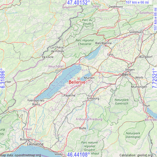
Bellerive GPS coordinates[2]
46° 55' 24.42" North, 7° 1' 19.524" East
| Map corner | latitude | longitude |
|---|---|---|
| Upper-left | 47.40152°, | 6.31896° |
| Center: | 46.92345°, | 7.02209° |
| Lower-right: | 46.44108°, | 7.72521° |
| Map W x H: | 106.8×106.8 km | = 66.4×66.4mi |
| max Lat: | 47.76737° ⇑68.3% North |
| Bellerive: | 46.92345° |
| min Lat: | ⇓31.7% South 45.83203° |
| min Long | Bellerive | max Long |
| 5.97153° | 7.02209° | 10.44624° |
| W 13%⇐ | ⇒87% E |
Elevation
Elevation of Bellerive is 533 m = 1749 ft, and this is 25.2 m = 83 ft below average elevation for this country.
| Max E: |
1845 m = 6053 ft | 37.5% |
| Avg. | 558.2 m = 1831 ft | |
| Bellerive | 533 m = 1749 ft | |
Min E: |
197 m = 646 ft | 62.5% |
See also: Switzerland elevation on elevation.city.
Geographical zone
Bellerive is located in North temperate zone (between Tropic of Cancer and the Arctic Circle). Distance of this North polar circle is 2183.8 km =1356.9 mi to North.| Distance of | km | miles | from Bellerive |
|---|---|---|---|
| North Pole | 4789.7 | 2976.2 | to North |
| Arctic Circle | 2183.8 | 1356.9 | to North |
| Tropic Cancer | 2611.5 | 1622.7 | to South |
| Equator | 5217.4 | 3241.9 | to South |


Nearby cities:
15 places around Bellerive: (largest is in red/bold)
• Avenches
5 km =3.1 mi,  163°
163°
• Bas-Vully
8.1 km =5 mi,  58°
58°
• Courgevaux
7.1 km =4.4 mi,  105°
105°
• Cudrefin
3.6 km =2.2 mi,  355°
355°
• Domdidier
6.3 km =3.9 mi,  186°
186°
• Dompierre
8.3 km =5.2 mi,  196°
196°
• Faoug
4.6 km =2.9 mi, 111°
• Gampelen
10.2 km =6.3 mi,  15°
15°
• Gletterens
7.2 km =4.5 mi,  243°
243°
• Grandcour
9.1 km =5.7 mi,  231°
231°
• Léchelles
10.5 km =6.5 mi,  182°
182°
• Marin-Epagnier
9.8 km =6.1 mi,  349°
349°
• Murten/Morat
7.2 km =4.5 mi,  85°
85°
• Münchenwiler
7.9 km =4.9 mi,  98°
98°
• Neuchâtel
10.3 km =6.4 mi,  317°
317°
Sources, notices
• [Note1] Compared only with cities in Switzerland existing in our database
• [Src1] Map data: © OpenStreetMap contributors (CC-BY-SA)
• [Src2] Other city data from geonames.org with taken over terms of usage.
• [Src3] Geographical zone / Annual Mean Temperature by Robert A. Rohde @ Wikipedia
