Gletterens geodata
Gletterens (Fribourg) is a populated place; located in Switzerland in Europe/Zurich (GMT+2) time zone. With population of 696 people, there are 1603 cities with bigger population in this country. Compared to other cities in Switzerland, 69.8% of cities are located further ↑North; 88.8% of cities are located further →East and 52.1% of cities have lower elevation than Gletterens. Note1


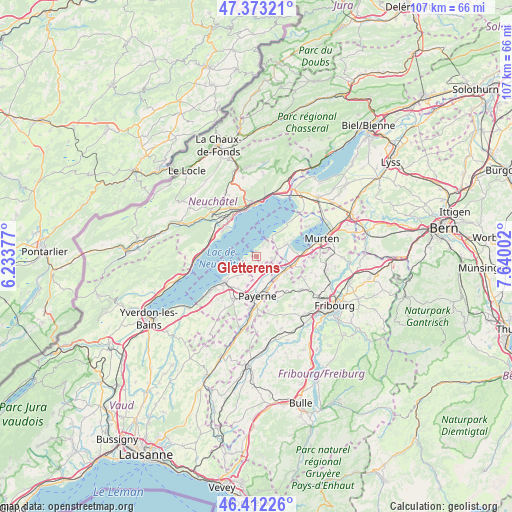
Gletterens GPS coordinates[2]
46° 53' 41.604" North, 6° 56' 12.804" East
| Map corner | latitude | longitude |
|---|---|---|
| Upper-left | 47.37321°, | 6.23377° |
| Center: | 46.89489°, | 6.93689° |
| Lower-right: | 46.41226°, | 7.64002° |
| Map W x H: | 106.8×106.8 km | = 66.4×66.4mi |
| max Lat: | 47.76737° ⇑69.8% North |
| Gletterens: | 46.89489° |
| min Lat: | ⇓30.2% South 45.83203° |
| min Long | Gletterens | max Long |
| 5.97153° | 6.93689° | 10.44624° |
| W 11.2%⇐ | ⇒88.8% E |
Elevation
Elevation of Gletterens is 485 m = 1591 ft, and this is 73.2 m = 240 ft below average elevation for this country.
| Max E: |
1845 m = 6053 ft | 47.9% |
| Avg. | 558.2 m = 1831 ft | |
| Gletterens | 485 m = 1591 ft | |
Min E: |
197 m = 646 ft | 52.1% |
See also: Switzerland elevation on elevation.city.
Geographical zone
Gletterens is located in North temperate zone (between Tropic of Cancer and the Arctic Circle). Distance of this North polar circle is 2187 km =1358.9 mi to North.| Distance of | km | miles | from Gletterens |
|---|---|---|---|
| North Pole | 4792.8 | 2978.1 | to North |
| Arctic Circle | 2187 | 1358.9 | to North |
| Tropic Cancer | 2608.3 | 1620.7 | to South |
| Equator | 5214.2 | 3240 | to South |


Nearby cities:
15 places around Gletterens: (largest is in red/bold)
• Auvernier
10 km =6.2 mi,  333°
333°
• Avenches
8.1 km =5 mi,  101°
101°
• Bellerive
7.2 km =4.5 mi,  63°
63°
• Bevaix
10.1 km =6.3 mi,  292°
292°
• Boudry
9.7 km =6 mi,  309°
309°
• Cortaillod
8.8 km =5.5 mi, 307°
• Cudrefin
9.2 km =5.7 mi,  42°
42°
• Cugy
9.6 km =6 mi,  202°
202°
• Domdidier
6.6 km =4.1 mi,  117°
117°
• Dompierre
6.3 km =3.9 mi,  139°
139°
• Estavayer-le-Lac
8.6 km =5.3 mi,  233°
233°
• Grandcour
2.6 km =1.6 mi,  194°
194°
• Lully
9.7 km =6 mi, 225°
• Léchelles
9.5 km =5.9 mi, 140°
• Payerne
8.1 km =5 mi,  179°
179°
Sources, notices
• [Note1] Compared only with cities in Switzerland existing in our database
• [Src1] Map data: © OpenStreetMap contributors (CC-BY-SA)
• [Src2] Other city data from geonames.org with taken over terms of usage.
• [Src3] Geographical zone / Annual Mean Temperature by Robert A. Rohde @ Wikipedia
