Urdorf / Bodenfeld geodata
Urdorf / Bodenfeld (Zurich) is a section of populated place; located in Switzerland in Europe/Zurich (GMT+2) time zone. With population of 1,840 people, there are 893 cities with bigger population in this country. Compared to other cities in Switzerland, 71% of cities are located further ↓South; 51% of cities are located further ←West and 85.1% of cities have higher elevation than Urdorf / Bodenfeld. Note1


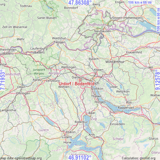
Urdorf / Bodenfeld GPS coordinates[2]
47° 23' 21.12" North, 8° 25' 21.54" East
| Map corner | latitude | longitude |
|---|---|---|
| Upper-left | 47.86308°, | 7.71953° |
| Center: | 47.3892°, | 8.42265° |
| Lower-right: | 46.91102°, | 9.12578° |
| Map W x H: | 105.9×105.9 km | = 65.8×65.8mi |
| max Lat: | 47.76737° ⇑29% North |
| Urdorf / Bodenfeld: | 47.3892° |
| min Lat: | ⇓71% South 45.83203° |
| min Long | Urdorf / Bodenf | max Long |
| 5.97153° | 8.42265° | 10.44624° |
| W 51%⇐ | ⇒49% E |
Elevation
Elevation of Urdorf / Bodenfeld is 410 m = 1345 ft, and this is 148.2 m = 486 ft below average elevation for this country.
| Max E: |
1845 m = 6053 ft | 85.1% |
| Avg. | 558.2 m = 1831 ft | |
| Urdorf / Bodenfeld | 410 m = 1345 ft | |
Min E: |
197 m = 646 ft | 14.9% |
See also: Switzerland elevation on elevation.city.
Geographical zone
Urdorf / Bodenfeld is located in North temperate zone (between Tropic of Cancer and the Arctic Circle). Distance of this North polar circle is 2132 km =1324.8 mi to North.| Distance of | km | miles | from Urdorf / Bodenfeld |
|---|---|---|---|
| North Pole | 4737.9 | 2944 | to North |
| Arctic Circle | 2132 | 1324.8 | to North |
| Tropic Cancer | 2663.3 | 1654.9 | to South |
| Equator | 5269.2 | 3274.1 | to South |


Nearby cities:
15 places around Urdorf / Bodenfeld: (largest is in red/bold)
• Dietikon / Guggenbühl
1.6 km =1 mi,  318°
318°
• Dietikon / Hofacker
1 km =0.6 mi,  330°
330°
• Dietikon / Schönenwerd
0.9 km =0.6 mi,  14°
14°
• Schlieren / Freiestrasse
1.6 km =1 mi,  62°
62°
• Schlieren / Pflugstrasse
1.3 km =0.8 mi,  51°
51°
• Schlieren / Spital
0.9 km =0.6 mi,  42°
42°
• Urdorf
0.5 km =0.3 mi,  152°
152°
• Urdorf / Baumgarten
1.1 km =0.7 mi,  186°
186°
• Urdorf / Fadmatt
0.9 km =0.6 mi, 151°
• Urdorf / Heidenkeller
0.6 km =0.4 mi,  141°
141°
• Urdorf / Moos
0.5 km =0.3 mi,  82°
82°
• Urdorf / Nieder-Urdorf
0.5 km =0.3 mi, 332°
• Urdorf / Ob der Bahn
0.8 km =0.5 mi,  107°
107°
• Urdorf / Oberurdorf
0.9 km =0.6 mi,  176°
176°
• Urdorf / Zentrum
0.4 km =0.2 mi,  166°
166°
Sources, notices
• [Note1] Compared only with cities in Switzerland existing in our database
• [Src1] Map data: © OpenStreetMap contributors (CC-BY-SA)
• [Src2] Other city data from geonames.org with taken over terms of usage.
• [Src3] Geographical zone / Annual Mean Temperature by Robert A. Rohde @ Wikipedia
