Degersheim geodata
Degersheim (Saint Gallen) is a populated place; located in Switzerland in Europe/Zurich (GMT+2) time zone. With population of 3,802 people, there are 469 cities with bigger population in this country. Compared to other cities in Switzerland, 68.7% of cities are located further ↓South; 92.9% of cities are located further ←West and 89.6% of cities have lower elevation than Degersheim. Note1


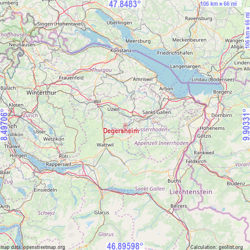
Degersheim GPS coordinates[2]
47° 22' 27.444" North, 9° 12' 0.684" East
| Map corner | latitude | longitude |
|---|---|---|
| Upper-left | 47.8483°, | 8.49706° |
| Center: | 47.37429°, | 9.20019° |
| Lower-right: | 46.89598°, | 9.90331° |
| Map W x H: | 105.9×105.9 km | = 65.8×65.8mi |
| max Lat: | 47.76737° ⇑31.3% North |
| Degersheim: | 47.37429° |
| min Lat: | ⇓68.7% South 45.83203° |
| min Long | Degersheim | max Long |
| 5.97153° | 9.20019° | 10.44624° |
| W 92.9%⇐ | ⇒7.1% E |
Elevation
Elevation of Degersheim is 814 m = 2671 ft, and this is 255.8 m = 839 ft above average elevation for this country.
| Max E: |
1845 m = 6053 ft | 10.4% |
| Degersheim | 814 m 2671 ft | |
| Avg. | 558.2 m = 1831 ft | |
Min E: |
197 m = 646 ft | 89.6% |
See also: Switzerland elevation on elevation.city.
Geographical zone
Degersheim is located in North temperate zone (between Tropic of Cancer and the Arctic Circle). Distance of this North polar circle is 2133.6 km =1325.8 mi to North.| Distance of | km | miles | from Degersheim |
|---|---|---|---|
| North Pole | 4739.5 | 2945 | to North |
| Arctic Circle | 2133.6 | 1325.8 | to North |
| Tropic Cancer | 2661.6 | 1653.8 | to South |
| Equator | 5267.5 | 3273.1 | to South |


Nearby cities:
15 places around Degersheim: (largest is in red/bold)
• Brunnadern
6.8 km =4.2 mi,  231°
231°
• Flawil
4.5 km =2.8 mi,  343°
343°
• Ganterschwil
8.2 km =5.1 mi,  275°
275°
• Gossau
6.2 km =3.9 mi,  41°
41°
• Hemberg
8.4 km =5.2 mi,  192°
192°
• Herisau
6.1 km =3.8 mi,  77°
77°
• Hundwil
9 km =5.6 mi,  96°
96°
• Mogelsberg
5.1 km =3.2 mi,  254°
254°
• Oberhelfenschwil
7 km =4.3 mi, 253°
• Oberuzwil
8.3 km =5.2 mi,  318°
318°
• Sankt Peterzell
6.5 km =4 mi,  196°
196°
• Schwellbrunn
4.4 km =2.7 mi,  123°
123°
• Urnäsch
8.8 km =5.5 mi,  136°
136°
• Uzwil
8.5 km =5.3 mi, 324°
• Waldstatt
6.6 km =4.1 mi,  107°
107°
Sources, notices
• [Note1] Compared only with cities in Switzerland existing in our database
• [Src1] Map data: © OpenStreetMap contributors (CC-BY-SA)
• [Src2] Other city data from geonames.org with taken over terms of usage.
• [Src3] Geographical zone / Annual Mean Temperature by Robert A. Rohde @ Wikipedia
