Bronschhofen geodata
Bronschhofen (Saint Gallen) is a populated place; located in Switzerland in Europe/Zurich (GMT+2) time zone. With population of 4,489 people, there are 384 cities with bigger population in this country. Compared to other cities in Switzerland, 86% of cities are located further ↓South; 89.5% of cities are located further ←West and 68.8% of cities have lower elevation than Bronschhofen. Note1


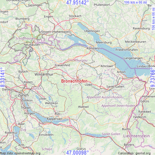
Bronschhofen GPS coordinates[2]
47° 28' 42.06" North, 9° 2' 4.344" East
| Map corner | latitude | longitude |
|---|---|---|
| Upper-left | 47.95142°, | 8.33141° |
| Center: | 47.47835°, | 9.03454° |
| Lower-right: | 47.00098°, | 9.73766° |
| Map W x H: | 105.7×105.7 km | = 65.7×65.7mi |
| max Lat: | 47.76737° ⇑14% North |
| Bronschhofen: | 47.47835° |
| min Lat: | ⇓86% South 45.83203° |
| min Long | Bronschhofen | max Long |
| 5.97153° | 9.03454° | 10.44624° |
| W 89.5%⇐ | ⇒10.5% E |
Elevation
Elevation of Bronschhofen is 566 m = 1857 ft, and this is 7.8 m = 26 ft above average elevation for this country.
| Max E: |
1845 m = 6053 ft | 31.2% |
| Bronschhofen | 566 m 1857 ft | |
| Avg. | 558.2 m = 1831 ft | |
Min E: |
197 m = 646 ft | 68.8% |
See also: Switzerland elevation on elevation.city.
Geographical zone
Bronschhofen is located in North temperate zone (between Tropic of Cancer and the Arctic Circle). Distance of this North polar circle is 2122.1 km =1318.6 mi to North.| Distance of | km | miles | from Bronschhofen |
|---|---|---|---|
| North Pole | 4728 | 2937.8 | to North |
| Arctic Circle | 2122.1 | 1318.6 | to North |
| Tropic Cancer | 2673.2 | 1661 | to South |
| Equator | 5279.1 | 3280.3 | to South |


Nearby cities:
15 places around Bronschhofen: (largest is in red/bold)
• Affeltrangen
5.3 km =3.3 mi,  358°
358°
• Eschlikon
5.6 km =3.5 mi,  252°
252°
• Fischingen
8.7 km =5.4 mi,  214°
214°
• Jonschwil
7.2 km =4.5 mi,  146°
146°
• Kirchberg
7.4 km =4.6 mi,  176°
176°
• Lommis
5.2 km =3.2 mi,  326°
326°
• Münchwilen
2.8 km =1.7 mi,  267°
267°
• Rickenbach bei Wil
3.5 km =2.2 mi,  161°
161°
• Sirnach
3.3 km =2.1 mi,  237°
237°
• Stettfurt
8.1 km =5 mi,  310°
310°
• Uzwil
8.8 km =5.5 mi,  121°
121°
• Wil
2 km =1.2 mi, 156°
• Wuppenau
5.9 km =3.7 mi,  70°
70°
• Wängi
6.4 km =4 mi,  288°
288°
• Zuzwil
5.8 km =3.6 mi,  94°
94°
Sources, notices
• [Note1] Compared only with cities in Switzerland existing in our database
• [Src1] Map data: © OpenStreetMap contributors (CC-BY-SA)
• [Src2] Other city data from geonames.org with taken over terms of usage.
• [Src3] Geographical zone / Annual Mean Temperature by Robert A. Rohde @ Wikipedia
