Affeltrangen geodata
Affeltrangen (Thurgau) is a populated place; located in Switzerland in Europe/Zurich (GMT+2) time zone. With population of 2,135 people, there are 797 cities with bigger population in this country. Compared to other cities in Switzerland, 92.7% of cities are located further ↓South; 89.4% of cities are located further ←West and 54.2% of cities have lower elevation than Affeltrangen. Note1


Affeltrangen GPS coordinates[2]
47° 31' 32.916" North, 9° 1' 59.052" East
| Map corner | latitude | longitude |
|---|---|---|
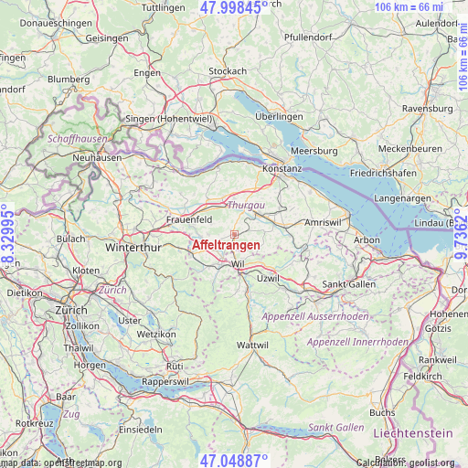
| Upper-left | 47.99845°, | 8.32995° |
| Center: | 47.52581°, | 9.03307° |
| Lower-right: | 47.04887°, | 9.7362° |
| Map W x H: | 105.6×105.6 km | = 65.6×65.6mi |
| max Lat: | 47.76737° ⇑7.3% North |
| Affeltrangen: | 47.52581° |
| min Lat: | ⇓92.7% South 45.83203° |
| min Long | Affeltrangen | max Long |
| 5.97153° | 9.03307° | 10.44624° |
| W 89.4%⇐ | ⇒10.6% E |
Elevation
Elevation of Affeltrangen is 492 m = 1614 ft, and this is 66.2 m = 217 ft below average elevation for this country.
| Max E: |
1845 m = 6053 ft | 45.8% |
| Avg. | 558.2 m = 1831 ft | |
| Affeltrangen | 492 m = 1614 ft | |
Min E: |
197 m = 646 ft | 54.2% |
See also: Switzerland elevation on elevation.city.
Geographical zone
Affeltrangen is located in North temperate zone (between Tropic of Cancer and the Arctic Circle). Distance of this North polar circle is 2116.8 km =1315.3 mi to North.| Distance of | km | miles | from Affeltrangen |
|---|---|---|---|
| North Pole | 4722.7 | 2934.5 | to North |
| Arctic Circle | 2116.8 | 1315.3 | to North |
| Tropic Cancer | 2678.5 | 1664.3 | to South |
| Equator | 5284.4 | 3283.6 | to South |


Nearby cities:
15 places around Affeltrangen: (largest is in red/bold)
• Bronschhofen
5.3 km =3.3 mi,  178°
178°
• Hüttlingen
7 km =4.3 mi,  325°
325°
• Lommis
2.9 km =1.8 mi,  250°
250°
• Matzingen
7.5 km =4.7 mi,  264°
264°
• Märstetten-Dorf
7.9 km =4.9 mi,  19°
19°
• Münchwilen
6.1 km =3.8 mi,  206°
206°
• Schönholzerswilen
8.2 km =5.1 mi,  96°
96°
• Sirnach
7.6 km =4.7 mi,  200°
200°
• Stettfurt
6 km =3.7 mi,  270°
270°
• Thundorf
5.7 km =3.5 mi,  293°
293°
• Weinfelden
6.8 km =4.2 mi,  47°
47°
• Wigoltingen
8 km =5 mi,  359°
359°
• Wil
7.2 km =4.5 mi,  172°
172°
• Wuppenau
6.6 km =4.1 mi,  119°
119°
• Wängi
6.8 km =4.2 mi,  241°
241°
Sources, notices
• [Note1] Compared only with cities in Switzerland existing in our database
• [Src1] Map data: © OpenStreetMap contributors (CC-BY-SA)
• [Src2] Other city data from geonames.org with taken over terms of usage.
• [Src3] Geographical zone / Annual Mean Temperature by Robert A. Rohde @ Wikipedia
