Sonnhalde geodata
Sonnhalde (Zurich) is a populated place; located in Switzerland in Europe/Zurich (GMT+2) time zone. With population of 1,984 people, there are 842 cities with bigger population in this country. Compared to other cities in Switzerland, 83% of cities are located further ↓South; 54.2% of cities are located further ←West and 65.3% of cities have higher elevation than Sonnhalde. Note1


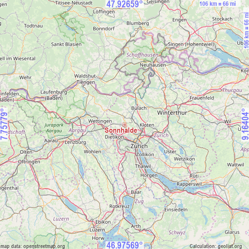
Sonnhalde GPS coordinates[2]
47° 27' 11.844" North, 8° 27' 39.276" East
| Map corner | latitude | longitude |
|---|---|---|
| Upper-left | 47.92659°, | 7.75779° |
| Center: | 47.45329°, | 8.46091° |
| Lower-right: | 46.97569°, | 9.16404° |
| Map W x H: | 105.7×105.7 km | = 65.7×65.7mi |
| max Lat: | 47.76737° ⇑17% North |
| Sonnhalde: | 47.45329° |
| min Lat: | ⇓83% South 45.83203° |
| min Long | Sonnhalde | max Long |
| 5.97153° | 8.46091° | 10.44624° |
| W 54.2%⇐ | ⇒45.8% E |
Elevation
Elevation of Sonnhalde is 446 m = 1463 ft, and this is 112.2 m = 368 ft below average elevation for this country.
| Max E: |
1845 m = 6053 ft | 65.3% |
| Avg. | 558.2 m = 1831 ft | |
| Sonnhalde | 446 m = 1463 ft | |
Min E: |
197 m = 646 ft | 34.7% |
See also: Switzerland elevation on elevation.city.
Geographical zone
Sonnhalde is located in North temperate zone (between Tropic of Cancer and the Arctic Circle). Distance of this North polar circle is 2124.9 km =1320.4 mi to North.| Distance of | km | miles | from Sonnhalde |
|---|---|---|---|
| North Pole | 4730.8 | 2939.6 | to North |
| Arctic Circle | 2124.9 | 1320.4 | to North |
| Tropic Cancer | 2670.4 | 1659.3 | to South |
| Equator | 5276.3 | 3278.5 | to South |


Nearby cities:
15 places around Sonnhalde: (largest is in red/bold)
• Adlikon
0.8 km =0.5 mi,  150°
150°
• Buchs / Buchs (Nord)
2.1 km =1.3 mi,  293°
293°
• Buchs / Ringstrasse
1.6 km =1 mi,  276°
276°
• Buchs / Zürcherstrasse
1.5 km =0.9 mi, 286°
• Dällikon / Dällikon (Dorf)
2.3 km =1.4 mi,  228°
228°
• Dällikon / Sytenacher
2.1 km =1.3 mi,  216°
216°
• Laubisser
1.3 km =0.8 mi,  115°
115°
• Regensdorf
2.2 km =1.4 mi,  164°
164°
• Regensdorf / Feldblumen-Riedthofstrasse
1.9 km =1.2 mi,  167°
167°
• Regensdorf / Hofacher-Geeren
2 km =1.2 mi,  176°
176°
• Regensdorf / Hubacher
2.6 km =1.6 mi, 179°
• Regensdorf / Obstgarten
2.9 km =1.8 mi, 172°
• Regensdorf / Watterstrasse
2.3 km =1.4 mi, 161°
• Regensdorf / Zentrum
2.6 km =1.6 mi, 166°
• Sand
1.9 km =1.2 mi,  136°
136°
Sources, notices
• [Note1] Compared only with cities in Switzerland existing in our database
• [Src1] Map data: © OpenStreetMap contributors (CC-BY-SA)
• [Src2] Other city data from geonames.org with taken over terms of usage.
• [Src3] Geographical zone / Annual Mean Temperature by Robert A. Rohde @ Wikipedia
