Grafstal geodata
Grafstal (Zurich) is a populated place; located in Switzerland in Europe/Zurich (GMT+2) time zone. With population of 501 people, there are 1807 cities with bigger population in this country. Compared to other cities in Switzerland, 81.3% of cities are located further ↓South; 74.2% of cities are located further ←West and 56.4% of cities have lower elevation than Grafstal. Note1


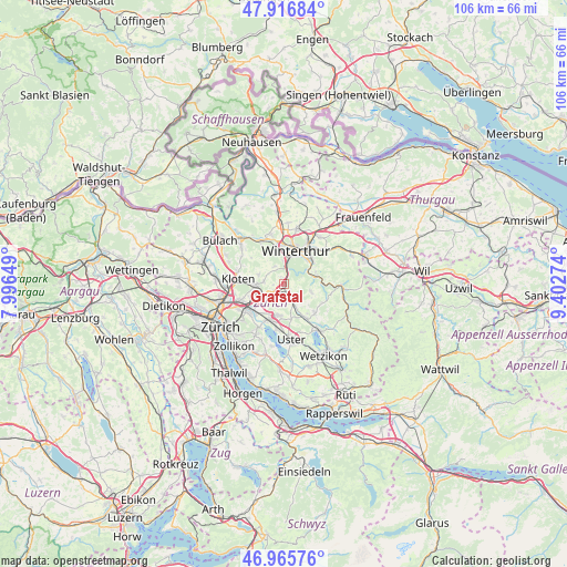
Grafstal GPS coordinates[2]
47° 26' 36.42" North, 8° 41' 58.596" East
| Map corner | latitude | longitude |
|---|---|---|
| Upper-left | 47.91684°, | 7.99649° |
| Center: | 47.44345°, | 8.69961° |
| Lower-right: | 46.96576°, | 9.40274° |
| Map W x H: | 105.8×105.7 km | = 65.7×65.7mi |
| max Lat: | 47.76737° ⇑18.7% North |
| Grafstal: | 47.44345° |
| min Lat: | ⇓81.3% South 45.83203° |
| min Long | Grafstal | max Long |
| 5.97153° | 8.69961° | 10.44624° |
| W 74.2%⇐ | ⇒25.8% E |
Elevation
Elevation of Grafstal is 503 m = 1650 ft, and this is 55.2 m = 181 ft below average elevation for this country.
| Max E: |
1845 m = 6053 ft | 43.6% |
| Avg. | 558.2 m = 1831 ft | |
| Grafstal | 503 m = 1650 ft | |
Min E: |
197 m = 646 ft | 56.4% |
See also: Switzerland elevation on elevation.city.
Geographical zone
Grafstal is located in North temperate zone (between Tropic of Cancer and the Arctic Circle). Distance of this North polar circle is 2126 km =1321 mi to North.| Distance of | km | miles | from Grafstal |
|---|---|---|---|
| North Pole | 4731.8 | 2940.2 | to North |
| Arctic Circle | 2126 | 1321 | to North |
| Tropic Cancer | 2669.3 | 1658.6 | to South |
| Equator | 5275.2 | 3277.9 | to South |


Nearby cities:
15 places around Grafstal: (largest is in red/bold)
• Brütten
3.8 km =2.4 mi,  331°
331°
• Effretikon
2.1 km =1.3 mi,  198°
198°
• Effretikon / Brandenriet / Vogelsang
2.7 km =1.7 mi, 203°
• Effretikon / Moosburg
2.5 km =1.6 mi,  193°
193°
• Effretikon / Rappenhalde-Bannhalde
2.2 km =1.4 mi, 186°
• Effretikon / Rikon
1.7 km =1.1 mi,  215°
215°
• Effretikon / Watt
1.7 km =1.1 mi,  183°
183°
• Illnau
3.9 km =2.4 mi,  155°
155°
• Illnau / Ober-Illnau
3.4 km =2.1 mi, 158°
• Lindau
2 km =1.2 mi,  268°
268°
• Nürensdorf
3.8 km =2.4 mi,  277°
277°
• Tagelswangen
2.5 km =1.6 mi,  234°
234°
• Töss (Kreis 4)
3.9 km =2.4 mi,  2°
2°
• Töss (Kreis 4) / Steig
3.4 km =2.1 mi, 3°
• Winterberg
1.5 km =0.9 mi,  344°
344°
Sources, notices
• [Note1] Compared only with cities in Switzerland existing in our database
• [Src1] Map data: © OpenStreetMap contributors (CC-BY-SA)
• [Src2] Other city data from geonames.org with taken over terms of usage.
• [Src3] Geographical zone / Annual Mean Temperature by Robert A. Rohde @ Wikipedia
