Seuzach Dorf / Breite-Weid geodata
Seuzach Dorf / Breite-Weid (Zurich) is a section of populated place; located in Switzerland in Europe/Zurich (GMT+2) time zone. With population of 1,016 people, there are 1315 cities with bigger population in this country. Compared to other cities in Switzerland, 93.4% of cities are located further ↓South; 77.4% of cities are located further ←West and 65.3% of cities have higher elevation than Seuzach Dorf / Breite-Weid. Note1
Current local time in Seuzach Dorf / Breite-Weid:
08:58 AM, SaturdayDifference from your time zone: hours


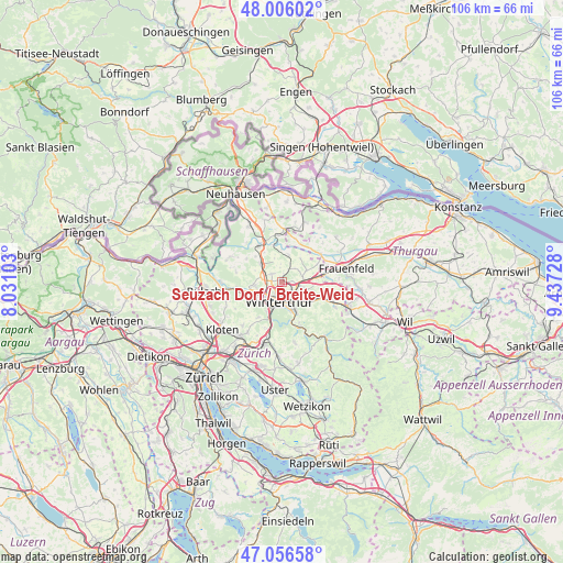
Seuzach Dorf / Breite-Weid GPS coordinates[2]
47° 32' 0.42" North, 8° 44' 2.94" East
| Map corner | latitude | longitude |
|---|---|---|
| Upper-left | 48.00602°, | 8.03103° |
| Center: | 47.53345°, | 8.73415° |
| Lower-right: | 47.05658°, | 9.43728° |
| Map W x H: | 105.6×105.6 km | = 65.6×65.6mi |
| max Lat: | 47.76737° ⇑6.6% North |
| Seuzach Dorf / Breite-Weid: | 47.53345° |
| min Lat: | ⇓93.4% South 45.83203° |
| min Long | Seuzach Dorf / | max Long |
| 5.97153° | 8.73415° | 10.44624° |
| W 77.4%⇐ | ⇒22.6% E |
Elevation
Elevation of Seuzach Dorf / Breite-Weid is 446 m = 1463 ft, and this is 112.2 m = 368 ft below average elevation for this country.
| Max E: |
1845 m = 6053 ft | 65.3% |
| Avg. | 558.2 m = 1831 ft | |
| Seuzach Dorf / Breite-Weid | 446 m = 1463 ft | |
Min E: |
197 m = 646 ft | 34.7% |
See also: Switzerland elevation on elevation.city.
Geographical zone
Seuzach Dorf / Breite-Weid is located in North temperate zone (between Tropic of Cancer and the Arctic Circle). Distance of this North polar circle is 2115.9 km =1314.8 mi to North.| Distance of | km | miles | from Seuzach Dorf / Breite-Weid |
|---|---|---|---|
| North Pole | 4721.8 | 2934 | to North |
| Arctic Circle | 2115.9 | 1314.8 | to North |
| Tropic Cancer | 2679.3 | 1664.8 | to South |
| Equator | 5285.2 | 3284.1 | to South |


Nearby cities:
15 places around Seuzach Dorf / Breite-Weid: (largest is in red/bold)
• Hettlingen
2.6 km =1.6 mi,  303°
303°
• Hettlingen / Dorfkern
2.5 km =1.6 mi,  306°
306°
• Hettlingen / Gübel
2.1 km =1.3 mi,  318°
318°
• Ober-Ohringen
1.7 km =1.1 mi,  243°
243°
• Oberwinterthur (Kreis 2)
3.2 km =2 mi,  125°
125°
• Oberwinterthur (Kreis 2) / Guggenbühl
3 km =1.9 mi,  138°
138°
• Oberwinterthur (Kreis 2) / Zinzikon
2.3 km =1.4 mi, 132°
• Seuzach / Seuzach (Dorf)
0.3 km =0.2 mi,  46°
46°
• Seuzach Dorf
0.3 km =0.2 mi,  327°
327°
• Seuzach Dorf / Brandbüel
0.7 km =0.4 mi,  58°
58°
• Seuzach Dorf / Hochgrüt-Scheidweg
0.4 km =0.2 mi,  217°
217°
• Seuzach Dorf / Pünten-Ifang
0.6 km =0.4 mi, 319°
• Stadt Winterthur (Kreis 1) / Lind
3.1 km =1.9 mi,  180°
180°
• Veltheim (Kreis 5)
2.5 km =1.6 mi,  211°
211°
• Veltheim (Kreis 5) / Rosenberg
2.6 km =1.6 mi, 212°
Sources, notices
• [Note1] Compared only with cities in Switzerland existing in our database
• [Src1] Map data: © OpenStreetMap contributors (CC-BY-SA)
• [Src2] Other city data from geonames.org with taken over terms of usage.
• [Src3] Geographical zone / Annual Mean Temperature by Robert A. Rohde @ Wikipedia
