Schwerzenbach geodata
Schwerzenbach (Zurich) is a populated place; located in Switzerland in Europe/Zurich (GMT+2) time zone. With population of 4,180 people, there are 416 cities with bigger population in this country. Compared to other cities in Switzerland, 69.4% of cities are located further ↓South; 70.9% of cities are located further ←West and 64.5% of cities have higher elevation than Schwerzenbach. Note1


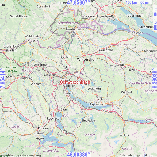
Schwerzenbach GPS coordinates[2]
47° 22' 55.668" North, 8° 39' 26.172" East
| Map corner | latitude | longitude |
|---|---|---|
| Upper-left | 47.85607°, | 7.95414° |
| Center: | 47.38213°, | 8.65727° |
| Lower-right: | 46.90389°, | 9.36039° |
| Map W x H: | 105.9×105.9 km | = 65.8×65.8mi |
| max Lat: | 47.76737° ⇑30.6% North |
| Schwerzenbach: | 47.38213° |
| min Lat: | ⇓69.4% South 45.83203° |
| min Long | Schwerzenbach | max Long |
| 5.97153° | 8.65727° | 10.44624° |
| W 70.9%⇐ | ⇒29.1% E |
Elevation
Elevation of Schwerzenbach is 447 m = 1467 ft, and this is 111.2 m = 365 ft below average elevation for this country.
| Max E: |
1845 m = 6053 ft | 64.5% |
| Avg. | 558.2 m = 1831 ft | |
| Schwerzenbach | 447 m = 1467 ft | |
Min E: |
197 m = 646 ft | 35.5% |
See also: Switzerland elevation on elevation.city.
Geographical zone
Schwerzenbach is located in North temperate zone (between Tropic of Cancer and the Arctic Circle). Distance of this North polar circle is 2132.8 km =1325.3 mi to North.| Distance of | km | miles | from Schwerzenbach |
|---|---|---|---|
| North Pole | 4738.7 | 2944.5 | to North |
| Arctic Circle | 2132.8 | 1325.3 | to North |
| Tropic Cancer | 2662.5 | 1654.4 | to South |
| Equator | 5268.4 | 3273.6 | to South |


Nearby cities:
15 places around Schwerzenbach: (largest is in red/bold)
• Dübendorf / Frickenbuck
2.2 km =1.4 mi,  296°
296°
• Dübendorf / Gfenn
1.4 km =0.9 mi,  325°
325°
• Fällanden
1.8 km =1.1 mi,  230°
230°
• Greifensee / Müllerwis / Seilerwis
2.2 km =1.4 mi,  125°
125°
• Greifensee / Ocht
1.8 km =1.1 mi,  122°
122°
• Hegnau
1.5 km =0.9 mi,  40°
40°
• Hegnau / Alt-Hegnau
1.5 km =0.9 mi,  60°
60°
• Hegnau / Dammboden-Grindel
0.9 km =0.6 mi,  51°
51°
• Hegnau / Im Zentrum
1.9 km =1.2 mi,  72°
72°
• Hegnau / Sunnebüel-Eich
2 km =1.2 mi, 55°
• Schwerzenbach / Blatten
0.6 km =0.4 mi,  280°
280°
• Schwerzenbach / Chimli
0.4 km =0.2 mi,  16°
16°
• Schwerzenbach / Chropfacher
0.2 km =0.1 mi,  348°
348°
• Schwerzenbach / Widacher
0.1 km =0.1 mi,  167°
167°
• Zimikon / Rütiwies
0.7 km =0.4 mi, 73°
Sources, notices
• [Note1] Compared only with cities in Switzerland existing in our database
• [Src1] Map data: © OpenStreetMap contributors (CC-BY-SA)
• [Src2] Other city data from geonames.org with taken over terms of usage.
• [Src3] Geographical zone / Annual Mean Temperature by Robert A. Rohde @ Wikipedia
