Greifensee / Müllerwis / Seilerwis geodata
Greifensee / Müllerwis / Seilerwis (Zurich) is a section of populated place; located in Switzerland in Europe/Zurich (GMT+2) time zone. With population of 1,064 people, there are 1287 cities with bigger population in this country. Compared to other cities in Switzerland, 67.6% of cities are located further ↓South; 72.7% of cities are located further ←West and 63.8% of cities have higher elevation than Greifensee / Müllerwis / Seilerwis. Note1
Current local time in Greifensee / Müllerwis / Seilerwis:
08:53 AM, SaturdayDifference from your time zone: hours


Greifensee / Müllerwis / Seilerwis GPS coordinates[2]
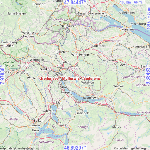
47° 22' 13.512" North, 8° 40' 53.436" East
| Map corner | latitude | longitude |
|---|---|---|
| Upper-left | 47.84447°, | 7.97838° |
| Center: | 47.37042°, | 8.68151° |
| Lower-right: | 46.89207°, | 9.38463° |
| Map W x H: | 105.9×105.9 km | = 65.8×65.8mi |
| max Lat: | 47.76737° ⇑32.4% North |
| Greifensee / Müllerwis / Seilerwis: | 47.37042° |
| min Lat: | ⇓67.6% South 45.83203° |
| min Long | Greifensee / M� | max Long |
| 5.97153° | 8.68151° | 10.44624° |
| W 72.7%⇐ | ⇒27.3% E |
Elevation
Elevation of Greifensee / Müllerwis / Seilerwis is 448 m = 1470 ft, and this is 110.2 m = 362 ft below average elevation for this country.
| Max E: |
1845 m = 6053 ft | 63.8% |
| Avg. | 558.2 m = 1831 ft | |
| Greifensee / Müllerwis / Seilerwis | 448 m = 1470 ft | |
Min E: |
197 m = 646 ft | 36.2% |
See also: Switzerland elevation on elevation.city.
Geographical zone
Greifensee / Müllerwis / Seilerwis is located in North temperate zone (between Tropic of Cancer and the Arctic Circle). Distance of this North polar circle is 2134.1 km =1326.1 mi to North.| Distance of | km | miles | from Greifensee / Müllerwis / Seilerwis |
|---|---|---|---|
| North Pole | 4740 | 2945.3 | to North |
| Arctic Circle | 2134.1 | 1326.1 | to North |
| Tropic Cancer | 2661.2 | 1653.6 | to South |
| Equator | 5267.1 | 3272.8 | to South |


Nearby cities:
15 places around Greifensee / Müllerwis / Seilerwis: (largest is in red/bold)
• Greifensee
0.4 km =0.2 mi,  184°
184°
• Greifensee / Ocht
0.5 km =0.3 mi,  316°
316°
• Greifensee / Pfisterhölzli
0.9 km =0.6 mi,  137°
137°
• Hegnau / Alt-Hegnau
2.1 km =1.3 mi,  346°
346°
• Hegnau / Dammboden-Grindel
2.2 km =1.4 mi,  328°
328°
• Hegnau / Im Zentrum
1.9 km =1.2 mi,  358°
358°
• Hegnau / Sunnebüel-Eich
2.5 km =1.6 mi, 355°
• Nänikon
0.6 km =0.4 mi,  97°
97°
• Nänikon / Nänikon (Dorfkern)
0.8 km =0.5 mi,  85°
85°
• Schwerzenbach
2.2 km =1.4 mi,  305°
305°
• Schwerzenbach / Chimli
2.4 km =1.5 mi, 315°
• Schwerzenbach / Chropfacher
2.4 km =1.5 mi, 308°
• Schwerzenbach / Widacher
2.2 km =1.4 mi,  304°
304°
• Volketswil / Volketswil (Dorf)
2.3 km =1.4 mi,  17°
17°
• Zimikon / Rütiwies
1.9 km =1.2 mi, 321°
Sources, notices
• [Note1] Compared only with cities in Switzerland existing in our database
• [Src1] Map data: © OpenStreetMap contributors (CC-BY-SA)
• [Src2] Other city data from geonames.org with taken over terms of usage.
• [Src3] Geographical zone / Annual Mean Temperature by Robert A. Rohde @ Wikipedia
