Greifensee / Ocht geodata
Greifensee / Ocht (Zurich) is a section of populated place; located in Switzerland in Europe/Zurich (GMT+2) time zone. With population of 980 people, there are 1342 cities with bigger population in this country. Compared to other cities in Switzerland, 68.4% of cities are located further ↓South; 72.2% of cities are located further ←West and 62.7% of cities have higher elevation than Greifensee / Ocht. Note1


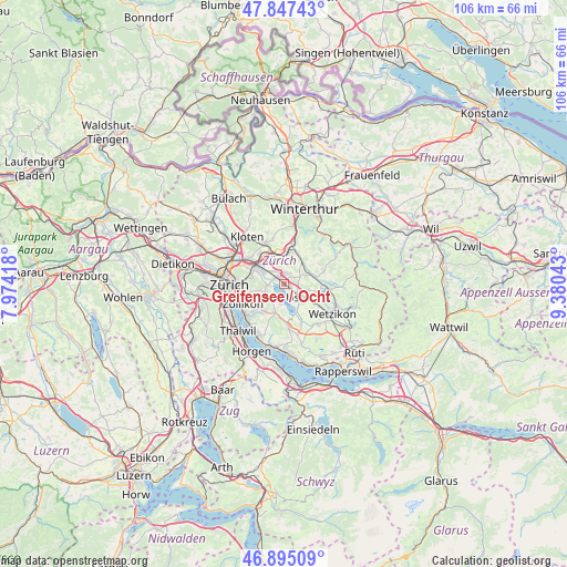
Greifensee / Ocht GPS coordinates[2]
47° 22' 24.276" North, 8° 40' 38.28" East
| Map corner | latitude | longitude |
|---|---|---|
| Upper-left | 47.84743°, | 7.97418° |
| Center: | 47.37341°, | 8.6773° |
| Lower-right: | 46.89509°, | 9.38043° |
| Map W x H: | 105.9×105.9 km | = 65.8×65.8mi |
| max Lat: | 47.76737° ⇑31.6% North |
| Greifensee / Ocht: | 47.37341° |
| min Lat: | ⇓68.4% South 45.83203° |
| min Long | Greifensee / Oc | max Long |
| 5.97153° | 8.6773° | 10.44624° |
| W 72.2%⇐ | ⇒27.8% E |
Elevation
Elevation of Greifensee / Ocht is 450 m = 1476 ft, and this is 108.2 m = 355 ft below average elevation for this country.
| Max E: |
1845 m = 6053 ft | 62.7% |
| Avg. | 558.2 m = 1831 ft | |
| Greifensee / Ocht | 450 m = 1476 ft | |
Min E: |
197 m = 646 ft | 37.3% |
See also: Switzerland elevation on elevation.city.
Geographical zone
Greifensee / Ocht is located in North temperate zone (between Tropic of Cancer and the Arctic Circle). Distance of this North polar circle is 2133.7 km =1325.8 mi to North.| Distance of | km | miles | from Greifensee / Ocht |
|---|---|---|---|
| North Pole | 4739.6 | 2945 | to North |
| Arctic Circle | 2133.7 | 1325.8 | to North |
| Tropic Cancer | 2661.5 | 1653.8 | to South |
| Equator | 5267.4 | 3273 | to South |


Nearby cities:
15 places around Greifensee / Ocht: (largest is in red/bold)
• Greifensee
0.8 km =0.5 mi,  157°
157°
• Greifensee / Müllerwis / Seilerwis
0.5 km =0.3 mi,  136°
136°
• Greifensee / Pfisterhölzli
1.4 km =0.9 mi, 137°
• Hegnau / Alt-Hegnau
1.7 km =1.1 mi,  353°
353°
• Hegnau / Dammboden-Grindel
1.7 km =1.1 mi,  332°
332°
• Hegnau / Im Zentrum
1.6 km =1 mi,  9°
9°
• Hegnau / Sunnebüel-Eich
2.1 km =1.3 mi,  3°
3°
• Nänikon
1 km =0.6 mi,  114°
114°
• Nänikon / Nänikon (Dorfkern)
1.2 km =0.7 mi,  103°
103°
• Schwerzenbach
1.8 km =1.1 mi,  302°
302°
• Schwerzenbach / Chimli
2 km =1.2 mi,  315°
315°
• Schwerzenbach / Chropfacher
1.9 km =1.2 mi,  306°
306°
• Schwerzenbach / Widacher
1.7 km =1.1 mi, 301°
• Volketswil / Volketswil (Dorf)
2.1 km =1.3 mi,  28°
28°
• Zimikon / Rütiwies
1.5 km =0.9 mi, 322°
Sources, notices
• [Note1] Compared only with cities in Switzerland existing in our database
• [Src1] Map data: © OpenStreetMap contributors (CC-BY-SA)
• [Src2] Other city data from geonames.org with taken over terms of usage.
• [Src3] Geographical zone / Annual Mean Temperature by Robert A. Rohde @ Wikipedia
