Pompaples geodata
Pompaples (Vaud) is a seat of a third-order administrative division; located in Switzerland in Europe/Zurich (GMT+1) time zone. In our database, there are 1823 cities with bigger population. Compared to other cities in Switzerland, 79.7% of cities are located further ↑North; 95.3% of cities are located further →East and 53.9% of cities have lower elevation than Pompaples. Note1


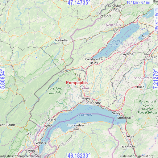
Pompaples GPS coordinates[2]
46° 40' 1.164" North, 6° 30' 34.776" East
| Map corner | latitude | longitude |
|---|---|---|
| Upper-left | 47.14735°, | 5.80654° |
| Center: | 46.66699°, | 6.50966° |
| Lower-right: | 46.18233°, | 7.21279° |
| Map W x H: | 107.3×107.3 km | = 66.7×66.7mi |
| max Lat: | 47.76737° ⇑79.7% North |
| Pompaples: | 46.66699° |
| min Lat: | ⇓20.3% South 45.83203° |
| min Long | Pompaples | max Long |
| 5.97153° | 6.50966° | 10.44624° |
| W 4.7%⇐ | ⇒95.3% E |
Elevation
Elevation of Pompaples is 491 m = 1611 ft, and this is 67.2 m = 220 ft below average elevation for this country.
| Max E: |
1845 m = 6053 ft | 46.1% |
| Avg. | 558.2 m = 1831 ft | |
| Pompaples | 491 m = 1611 ft | |
Min E: |
197 m = 646 ft | 53.9% |
See also: Switzerland elevation on elevation.city.
Geographical zone
Pompaples is located in North temperate zone (between Tropic of Cancer and the Arctic Circle). Distance of this North polar circle is 2212.3 km =1374.7 mi to North.| Distance of | km | miles | from Pompaples |
|---|---|---|---|
| North Pole | 4818.2 | 2993.9 | to North |
| Arctic Circle | 2212.3 | 1374.7 | to North |
| Tropic Cancer | 2583 | 1605 | to South |
| Equator | 5188.9 | 3224.2 | to South |


Nearby cities:
15 places around Pompaples: (largest is in red/bold)
• Bavois
4.8 km =3 mi,  66°
66°
• Chavornay
6 km =3.7 mi,  49°
49°
• Chevilly
3.7 km =2.3 mi,  223°
223°
• Cossonay
5.8 km =3.6 mi,  182°
182°
• Cuarnens
7.2 km =4.5 mi,  230°
230°
• Daillens
5.9 km =3.7 mi,  149°
149°
• Ferreyres
2.1 km =1.3 mi,  241°
241°
• Goumoens-la-Ville
7.2 km =4.5 mi,  96°
96°
• La Chaux
6.2 km =3.9 mi,  207°
207°
• La Sarraz
0.9 km =0.6 mi,  174°
174°
• Moiry
4.7 km =2.9 mi,  245°
245°
• Orbe
6.7 km =4.2 mi,  13°
13°
• Orny
1.3 km =0.8 mi,  87°
87°
• Penthalaz
6.4 km =4 mi, 169°
• Penthéréaz
7.4 km =4.6 mi,  77°
77°
Sources, notices
• [Note1] Compared only with cities in Switzerland existing in our database
• [Src1] Map data: © OpenStreetMap contributors (CC-BY-SA)
• [Src2] Other city data from geonames.org with taken over terms of usage.
• [Src3] Geographical zone / Annual Mean Temperature by Robert A. Rohde @ Wikipedia
