Odienné geodata
Odienné (Denguélé) is a seat of a first-order administrative division; located in Ivory Coast in Africa/Abidjan (GMT+0) time zone. With population of 49,857 people, there are 27 cities with bigger population in this country. Compared to other cities in Ivory Coast, 88.9% of cities are located further ↓South; 90.6% of cities are located further →East and 94.9% of cities have lower elevation than Odienné. Note1


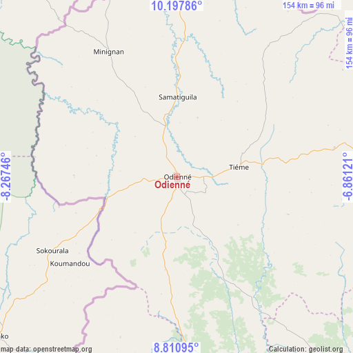
Odienné GPS coordinates[2]
9° 30' 18.396" North, 7° 33' 51.588" West
| Map corner | latitude | longitude |
|---|---|---|
| Upper-left | 10.19786°, | -8.26746° |
| Center: | 9.50511°, | -7.56433° |
| Lower-right: | 8.81095°, | -6.86121° |
| Map W x H: | 154.2×154.2 km | = 95.8×95.8mi |
| max Lat: | 10.48115° ⇑11.1% North |
| Odienné: | 9.50511° |
| min Lat: | ⇓88.9% South 4.42295° |
| min Long | Odienné | max Long |
| -8.42592° | -7.56433° | -2.80003° |
| W 9.4%⇐ | ⇒90.6% E |
Elevation
Elevation of Odienné is 429 m = 1407 ft, and this is 204.7 m = 672 ft above average elevation for this country.
| Max E: |
556 m = 1824 ft | 5.1% |
| Odienné | 429 m 1407 ft | |
| Avg. | 224.3 m = 736 ft | |
Min E: |
7 m = 23 ft | 94.9% |
See also: Odienné elevation on elevation.city.
Geographical zone
Odienné is located in North Torrid zone (between Equator and Tropic of Cancer). Distance of Equator is 1056.9 km =656.7 mi to South.| Distance of | km | miles | from Odienné |
|---|---|---|---|
| North Pole | 8950.2 | 5561.4 | to North |
| Arctic Circle | 6344.3 | 3942.2 | to North |
| Tropic Cancer | 1549 | 962.5 | to North |
| Equator | 1056.9 | 656.7 | to South |


Nearby cities:
15 places around Odienné: (largest is in red/bold)
• Boundiali
118.2 km =73.4 mi,  89°
89°
• Dianra
156.7 km =97.4 mi,  113°
113°
• Gbéléban
62.9 km =39.1 mi,  278°
278°
• Kani
155.4 km =96.6 mi,  137°
137°
• Kaniasso
34.9 km =21.7 mi,  9°
9°
• Koro
106.2 km =66 mi,  174°
174°
• Kouto
133.6 km =83 mi,  71°
71°
• Madinani
69.2 km =43 mi,  80°
80°
• Minignan
62.3 km =38.7 mi,  331°
331°
• M’Bengué
190.5 km =118.4 mi, 73°
• Ouaninou
144.8 km =90 mi,  193°
193°
• Samatiguila
35 km =21.7 mi,  0°
0°
• Séguélon
51.4 km =31.9 mi, 108°
• Tengréla
166.9 km =103.7 mi,  49°
49°
• Touba
136.5 km =84.8 mi, 185°
Sources, notices
• [Note1] Compared only with cities in Ivory Coast existing in our database
• [Src1] Map data: © OpenStreetMap contributors (CC-BY-SA)
• [Src2] Other city data from geonames.org with taken over terms of usage.
• [Src3] Geographical zone / Annual Mean Temperature by Robert A. Rohde @ Wikipedia
